|
search place name
|
||
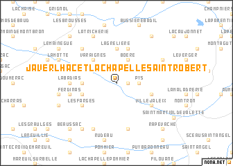
Javerlhac-et-la-Chapelle-Saint-Robert (Aquitaine, France)Javerlhac-et-la-Chapelle-Saint-Robert is a town in the Aquitaine region of France. An overview map of the region around Javerlhac-et-la-Chapelle-Saint-Robert is displayed below.
regional and 3d topo map of Javerlhac-et-la-Chapelle-Saint-Robert, France ::
Javerlhac-et-la-Chapelle-Saint-Robert airports ::
The nearest airport is ANG - Angouleme Brie Champniers, located 32.4 km north west of Javerlhac-et-la-Chapelle-Saint-Robert.
Other airports nearby include PGX - Perigueux Bassillac (45.4 km south east), LIG - Limoges Bellegarde (58.0 km north east), CNG - Cognac Chateaubernard (69.7 km west), EGC - Bergerac Roumaniere (82.5 km south), Nearby towns ::
Tassat (1.3km east) //
Teyjat (2.3km north east) //
Pys (2.6km east) //
Boëre (3.9km north) //
Varaignes (4.5km north west) //
La Chapelle-Saint-Robert (3.9km west) //
La Grelière (5.6km north) //
Le Grand Moulin (4.3km north west) //
Soudat (5.7km north) //
Buzetière (4.3km south west) //
Saint-Martin-le-Pin (4.3km south east) //
Les Farges (5.4km south west) //
Villejaleix (5.4km south east) //
Labadias (5.2km west) //
Le Bourdeix (5.5km east) //
Lussas-et-Nontronneau (7.5km south) //
La Cécile (5.5km west) //
Souffrignac (5.5km west) //
Ferdinas (5.5km west) //
Chez Maroc (6.8km north west) //
Étouars (6.4km north east) //
La Tricherie (7.9km north) //
La Brousse (7.9km south) //
Les Tuillères (8.4km north east) //
Connezac (8.4km south west) //
Chez Vincent (9.0km north west) //
Rapevache (9.1km south east) //
Beaussac (9.1km south west) //
[all distances 'as the bird flies' and approximate] 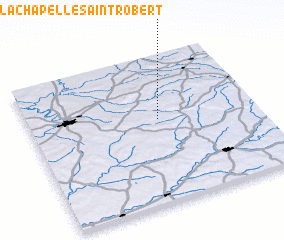 Places with similar names to Javerlhac-et-la-Chapelle-Saint-Robert, France :: Disclaimer :: Information on this page comes without warranty of any kind |
||
|
Where is Javerlhac-et-la-Chapelle-Saint-Robert? Elevation and coordinates ::
Latitude (lat): 45°34'0"N Longitude (lon): 0°34'0"W
Elevation (approx.): 149m (map arrows pan, magnifying glasses zoom) |
||
|
Visiting Javerlhac-et-la-Chapelle-Saint-Robert? Hotel/Accommodation ::
Book a hotel in Javerlhac-et-la-Chapelle-Saint-Robert Travel Guide ::
Buy a travel guide for France rental cars ::
car rental offers GPS waypoint ::
download a GPX waypoint (PoI) of Javerlhac-et-la-Chapelle-Saint-Robert for your GPS receiver
|
||