|
search place name
|
||
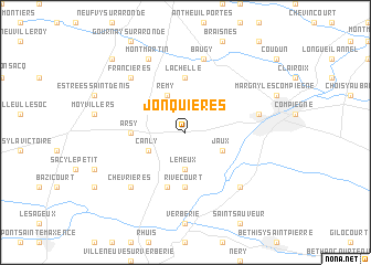
Jonquières (Picardie, France)Jonquières is a town in the Picardie region of France. An overview map of the region around Jonquières is displayed below.
regional and 3d topo map of Jonquières, France ::
Jonquières airports ::
The nearest airport is CSF - Creil, located 22.5 km south west of Jonquières.
Other airports nearby include CDG - Paris Charles De Gaulle (45.1 km south), BVA - Beauvais Tille (45.4 km west), LBG - Paris Le Bourget (52.4 km south west), POX - Pontoise Cormeilles En Vexin (60.7 km south west), Nearby towns ::
Le Meux (3.7km south) //
Rémy (3.9km north) //
Le Fayel (3.0km south west) //
Canly (3.0km south west) //
Jaux (3.0km south east) //
Armancourt (3.0km south east) //
Rivecourt (5.6km south) //
Arsy (3.6km west) //
Lachelle (5.6km north) //
Longueil-Sainte-Marie (5.7km south) //
Monchy-Humières (7.5km north) //
Baugy (7.5km north) //
Venette (5.2km east) //
Chevrières (6.6km south west) //
Lacroix-Saint-Ouen (6.6km south east) //
Francières (6.6km north west) //
Montmartin (7.8km north) //
Hémévillers (8.8km north west) //
[all distances 'as the bird flies' and approximate]  Places with similar names to Jonquières, France ::
// Junqueiros (PT)
// Juan Cruz (CU)
// Junqueiras (ES)
// June Acres (US)
// Geyn-Keriz (TM)
// Jonquières (FR)
// Jonquières (FR)
// Jonquières (FR)
// Jonquières (FR)
// Junkars (FI)
Disclaimer :: Information on this page comes without warranty of any kind |
||
|
Where is Jonquières? Elevation and coordinates ::
Latitude (lat): 49°24'0"N Longitude (lon): 2°44'0"E
Elevation (approx.): 77m (map arrows pan, magnifying glasses zoom) |
||
|
Visiting Jonquières? Hotel/Accommodation ::
Book a hotel in Jonquières Travel Guide ::
Buy a travel guide for France rental cars ::
car rental offers GPS waypoint ::
download a GPX waypoint (PoI) of Jonquières for your GPS receiver
|
||