|
search place name
|
||
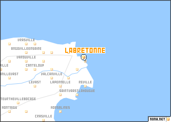
La Bretonne (Basse-Normandie, France)La Bretonne is a town in the Basse-Normandie region of France. An overview map of the region around La Bretonne is displayed below.
regional and 3d topo map of La Bretonne, France ::
La Bretonne airports ::
The nearest airport is CER - Cherbourg Maupertus, located 16.0 km west of La Bretonne.
Other airports nearby include ACI - Alderney (69.8 km west), CFR - Caen Carpiquet (79.9 km south east), JER - Jersey (85.5 km south west), LEH - Le Havre Octeville (97.8 km east), Nearby towns ::
Barfleur (0.0km north) //
Montfarville (2.2km south west) //
Gatteville-le-Phare (3.0km north west) //
Anneville-en-Saire (4.4km south west) //
Réville (5.6km south) //
Gouberville (5.1km west) //
Saint-Vaast-la-Hougue (7.5km south) //
Sainte-Geneviève (5.1km west) //
La Pernelle (6.6km south west) //
Valcanville (6.1km south west) //
Le Vicel (6.1km south west) //
Quettehou (8.2km south west) //
[all distances 'as the bird flies' and approximate]  Places with similar names to La Bretonne, France ::
// Libertinia (IT)
// Libardón (ES)
// La Bretaña (CO)
// Labretonie (FR)
// Le Bardon (FR)
// Libberton (GB)
// Liberton (GB)
// Labardén (AR)
// La Bertine (FR)
// La Bertinie (FR)
Disclaimer :: Information on this page comes without warranty of any kind |
||
|
Where is La Bretonne? Elevation and coordinates ::
Latitude (lat): 49°40'0"N Longitude (lon): 1°15'0"W
Elevation (approx.): -32768m (map arrows pan, magnifying glasses zoom) |
||
|
Visiting La Bretonne? Hotel/Accommodation ::
Book a hotel in La Bretonne Travel Guide ::
Buy a travel guide for France rental cars ::
car rental offers GPS waypoint ::
download a GPX waypoint (PoI) of La Bretonne for your GPS receiver
|
||