|
search place name
|
||
La Bruyère (Franche-Comté, France)La Bruyère is a town in the Franche-Comté region of France. An overview map of the region around La Bruyère is displayed below.
regional and 3d topo map of La Bruyère, France ::

La Bruyère airports ::
The nearest airport is EPL - Epinal Mirecourt, located 62.7 km north west of La Bruyère.
Other airports nearby include CMR - Colmar Houssen (72.3 km north east), MLH - Bale Mulhouse (83.1 km east), ENC - Nancy Essey (97.3 km north), SXB - Strassbourg Entzheim (115.7 km north east), Nearby towns ::
Breuchotte (1.2km west) //
La Proiselière-et-Langle (1.2km east) //
Amage (1.2km east) //
Raddon-et-Chapendu (1.9km north) //
Sainte-Marie-en-Chanois (2.5km east) //
La Corbière (3.9km south) //
Esboz-Brest (4.5km south west) //
Saint-Bresson (4.5km north east) //
La Voivre (3.7km east) //
Magnivray (5.7km south) //
Belmont (5.7km south) //
La Lanterne-et-les-Armonts (5.3km south east) //
Rignovelle (7.4km south) //
Froideconche (5.3km west) //
[all distances 'as the bird flies' and approximate] 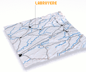 Places with similar names to La Bruyère, France ::
// La Bruyère (HT)
// La Bruyère (FR)
// La Bruyère (FR)
// La Bruyère (FR)
// La Bruyère (FR)
// La Bruyère (FR)
// La Bruyère (FR)
// La Bruyère (FR)
// La Bruyère (FR)
// Labruyère (FR)
Disclaimer :: Information on this page comes without warranty of any kind |
||
|
Where is La Bruyère? Elevation and coordinates ::
Latitude (lat): 47°50'0"N Longitude (lon): 6°29'0"E
Elevation (approx.): 342m (map arrows pan, magnifying glasses zoom) |
||
|
Visiting La Bruyère? Hotel/Accommodation ::
Book a hotel in La Bruyère Travel Guide ::
Buy a travel guide for France rental cars ::
car rental offers GPS waypoint ::
download a GPX waypoint (PoI) of La Bruyère for your GPS receiver
|
||