|
search place name
|
||
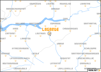
La Garde (Auvergne, France)La Garde is a town in the Auvergne region of France. An overview map of the region around La Garde is displayed below.
regional and 3d topo map of La Garde, France ::
La Garde airports ::
The nearest airport is AUR - Aurillac, located 40.9 km west of La Garde.
Other airports nearby include RDZ - Rodez Marcillac (59.3 km south west), MEN - Mende Brenoux (60.1 km south east), LPY - Le Puy Loudes (71.0 km north east), CFE - Clermont Ferrand Auvergne (107.6 km north), Nearby towns ::
Lieutadès (2.6km west) //
Le Vialard (3.9km north) //
Espinasse (3.9km north) //
Jabrun (4.5km south east) //
Sainte-Marie (5.4km north west) //
Chaudes-Aigues (5.6km east) //
Cros (6.8km north east) //
Lacalm (8.4km south west) //
[all distances 'as the bird flies' and approximate] 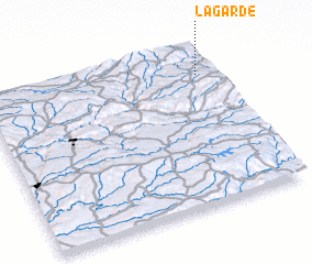 Places with similar names to La Garde, France ::
Disclaimer :: Information on this page comes without warranty of any kind |
||
|
Where is La Garde? Elevation and coordinates ::
Latitude (lat): 44°50'0"N Longitude (lon): 2°56'0"E
Elevation (approx.): 823m (map arrows pan, magnifying glasses zoom) |
||
|
Visiting La Garde? Hotel/Accommodation ::
Book a hotel in La Garde Travel Guide ::
Buy a travel guide for France rental cars ::
car rental offers GPS waypoint ::
download a GPX waypoint (PoI) of La Garde for your GPS receiver
|
||