|
search place name
|
||
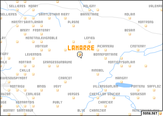
La Marre (Franche-Comté, France)La Marre is a town in the Franche-Comté region of France. An overview map of the region around La Marre is displayed below.
regional and 3d topo map of La Marre, France ::
La Marre airports ::
The nearest airport is DLE - Dole Tavaux, located 39.8 km north west of La Marre.
Other airports nearby include GVA - Geneva Cointrin (63.4 km south east), XBK - Bourg Ceyzeriat (67.0 km south west), XCD - Chalon Champforgeuil (68.2 km west), QNJ - Annemasse (74.3 km south east), Nearby towns ::
Blois-sur-Seille (3.1km north west) //
Fay-en-Montagne (3.1km north east) //
Ladoye-sur-Seille (3.9km north) //
Le Fied (3.9km north) //
Mirebel (4.5km south east) //
Bonnefontaine (3.8km east) //
Granges-sur-Baume (4.2km south west) //
Picarreau (4.2km north east) //
Crançot (6.1km south west) //
Baume-les-Messieurs (5.4km west) //
Plasne (7.5km north) //
Nevy-sur-Seille (5.4km west) //
Château-Chalon (5.4km west) //
Vevy (8.3km south west) //
Villard-sur-lʼAin (8.3km south east) //
[all distances 'as the bird flies' and approximate] 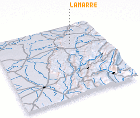 Places with similar names to La Marre, France ::
Disclaimer :: Information on this page comes without warranty of any kind |
||
|
Where is La Marre? Elevation and coordinates ::
Latitude (lat): 46°44'0"N Longitude (lon): 5°42'0"E
Elevation (approx.): 526m (map arrows pan, magnifying glasses zoom) |
||
|
Visiting La Marre? Hotel/Accommodation ::
Book a hotel in La Marre Travel Guide ::
Buy a travel guide for France rental cars ::
car rental offers GPS waypoint ::
download a GPX waypoint (PoI) of La Marre for your GPS receiver
|
||