|
search place name
|
||
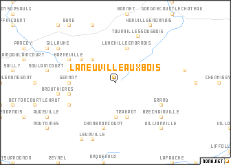
Laneuville-aux-Bois (Champagne-Ardenne, France)Laneuville-aux-Bois is a town in the Champagne-Ardenne region of France. An overview map of the region around Laneuville-aux-Bois is displayed below.
regional and 3d topo map of Laneuville-aux-Bois, France ::
Laneuville-aux-Bois airports ::
The nearest airport is EPL - Epinal Mirecourt, located 49.5 km east of Laneuville-aux-Bois.
Other airports nearby include ENC - Nancy Essey (67.4 km north east), ETZ - Metz Nancy Lorraine (87.9 km north east), MZM - Metz Frescaty (89.8 km north east), QYR - Troyes Barberey (104.3 km west), Nearby towns ::
Lezéville (3.1km north west) //
Cirfontaines-en-Ornois (4.4km north west) //
Morionvilliers (5.6km south) //
Luméville-en-Ornois (5.7km north) //
Chassey-Beaupré (5.7km north) //
Trampot (5.7km south) //
Rémoiville (5.2km north west) //
Germay (4.9km west) //
Bressoncourt (5.3km west) //
Chambroncourt (7.5km south) //
Germisay (5.3km west) //
Tourailles-sous-Bois (7.8km north) //
Grand (6.2km south east) //
Harméville (6.2km north west) //
Épizon (6.2km south west) //
Bréchainville (7.4km south east) //
Aillianville (8.9km south east) //
[all distances 'as the bird flies' and approximate] 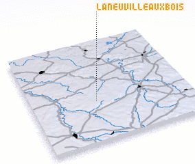 Places with similar names to Laneuville-aux-Bois, France ::
// La Neuville-aux-Bois (FR)
Disclaimer :: Information on this page comes without warranty of any kind |
||
|
Where is Laneuville-aux-Bois? Elevation and coordinates ::
Latitude (lat): 48°25'0"N Longitude (lon): 5°25'0"E
Elevation (approx.): 326m (map arrows pan, magnifying glasses zoom) |
||
|
Visiting Laneuville-aux-Bois? Hotel/Accommodation ::
Book a hotel in Laneuville-aux-Bois Travel Guide ::
Buy a travel guide for France rental cars ::
car rental offers GPS waypoint ::
download a GPX waypoint (PoI) of Laneuville-aux-Bois for your GPS receiver
|
||