|
search place name
|
||
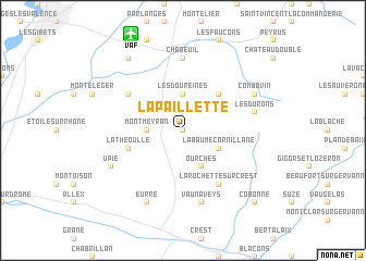
La Paillette (Rhône-Alpes, France)La Paillette is a town in the Rhône-Alpes region of France. An overview map of the region around La Paillette is displayed below.
regional and 3d topo map of La Paillette, France ::
La Paillette airports ::
The nearest airport is VAF - Valence Chabeuil, located 10.5 km north of La Paillette.
Other airports nearby include OBS - Aubenas-vals-lanas Ardeche Meridionale (60.4 km south west), GNB - Grenoble Saint Geoirs (63.8 km north east), EBU - St.-etienne Boutheon (96.9 km north west), LYS - Lyon Saint Exupery (99.4 km north), Nearby towns ::
Les Rorivas (0.0km north) //
Les Auléas (2.3km north east) //
Montmeyran (2.6km west) //
Montvendre (3.7km north) //
Les Doureines (3.7km north) //
La Baume-Cornillane (3.2km south east) //
Ourches (3.9km south) //
Barcelonne (4.5km north east) //
La Théoulle (4.4km south west) //
La Rochette-sur-Crest (6.2km south east) //
Beaumont-lès-Valence (5.4km north west) //
Chabeuil (7.4km north) //
Vaunaveys (7.5km south) //
Les Durons (5.6km east) //
Eurre (7.9km south) //
Combovin (6.4km north east) //
Upie (6.4km south west) //
Malissard (8.4km north west) //
Cobonne (9.1km south east) //
[all distances 'as the bird flies' and approximate] 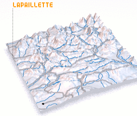 Places with similar names to La Paillette, France ::
Disclaimer :: Information on this page comes without warranty of any kind |
||
|
Where is La Paillette? Elevation and coordinates ::
Latitude (lat): 44°50'0"N Longitude (lon): 5°1'0"E
Elevation (approx.): 262m (map arrows pan, magnifying glasses zoom) |
||
|
Visiting La Paillette? Hotel/Accommodation ::
Book a hotel in La Paillette Travel Guide ::
Buy a travel guide for France rental cars ::
car rental offers GPS waypoint ::
download a GPX waypoint (PoI) of La Paillette for your GPS receiver
|
||