|
search place name
|
||
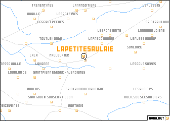
La Petite Saulaie (Pays de la Loire, France)La Petite Saulaie is a town in the Pays de la Loire region of France. An overview map of the region around La Petite Saulaie is displayed below.
regional and 3d topo map of La Petite Saulaie, France ::
La Petite Saulaie airports ::
The nearest airport is CET - Cholet Le Pontreau, located 15.3 km north west of La Petite Saulaie.
Other airports nearby include EDM - La Roche-sur-yon Les Ajoncs (62.5 km south west), NTE - Nantes Atlantique (70.8 km west), NIT - Niort Souche (81.7 km south), PIS - Poitiers Biard (90.4 km south east), Nearby towns ::
Yzernay (0.0km north) //
La Brosse (1.9km north) //
LʼOucherie (4.5km north east) //
La Fredonnière (4.5km north east) //
Maulévrier (3.8km west) //
Les Cerqueux-de-Maulévrier (4.2km south east) //
les Places (6.1km north east) //
Saint-Pierre-des-Échaubrognes (5.3km south west) //
Saint-Aubin-de-Baubigné (7.4km south) //
Les Fontenits (6.7km north east) //
Toutlemonde (6.3km north west) //
Les Gautrêches (9.0km north west) //
[all distances 'as the bird flies' and approximate] 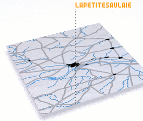 Places with similar names to La Petite Saulaie, France ::
// La Petite Celle (FR)
Disclaimer :: Information on this page comes without warranty of any kind |
||
|
Where is La Petite Saulaie? Elevation and coordinates ::
Latitude (lat): 47°1'0"N Longitude (lon): 0°42'0"W
Elevation (approx.): 161m (map arrows pan, magnifying glasses zoom) |
||
|
Visiting La Petite Saulaie? Hotel/Accommodation ::
Book a hotel in La Petite Saulaie Travel Guide ::
Buy a travel guide for France rental cars ::
car rental offers GPS waypoint ::
download a GPX waypoint (PoI) of La Petite Saulaie for your GPS receiver
|
||