|
search place name
|
||
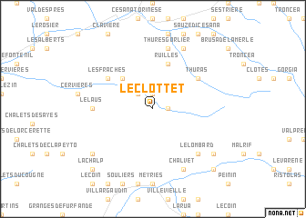
Le Clottet (Provence-Alpes-Côte dʼAzur, France)Le Clottet is a town in the Provence-Alpes-Côte dʼAzur region of France. An overview map of the region around Le Clottet is displayed below.
regional and 3d topo map of Le Clottet, France ::
Le Clottet airports ::
The nearest airport is CUF - Levaldigi, located 73.4 km south east of Le Clottet.
Other airports nearby include TRN - Torino (77.5 km north east), CMF - Chambery Aix Les Bains (113.5 km north west), GNB - Grenoble Saint Geoirs (129.0 km north west), NCY - Annecy Meythet (131.9 km north west), Nearby towns ::
Les Fonts (1.3km east) //
Les Chalps (1.9km north) //
Prafauchier (2.3km north west) //
Le Bourget (4.5km north west) //
Chabaud (5.7km north) //
Ruilles (5.7km north) //
Lachau (5.4km north west) //
Thuras (5.4km north east) //
Les Fraches (5.4km north west) //
Le Laus (5.3km west) //
Le Blétonnet (5.3km west) //
Thures Gorlier (7.5km north) //
Le Lombard (6.8km south east) //
Champ Quartier (7.9km north) //
Chalvet (7.9km south) //
Eygliers (7.7km south east) //
Brunissard (7.7km south west) //
Aiguilles (9.1km south east) //
La Chalp (9.1km south west) //
[all distances 'as the bird flies' and approximate]  Places with similar names to Le Clottet, France ::
// Llicaldad (CL)
// La Igualdad (VE)
Disclaimer :: Information on this page comes without warranty of any kind |
||
|
Where is Le Clottet? Elevation and coordinates ::
Latitude (lat): 44°51'0"N Longitude (lon): 6°48'0"E
Elevation (approx.): 2132m (map arrows pan, magnifying glasses zoom) |
||
|
Visiting Le Clottet? Hotel/Accommodation ::
Book a hotel in Le Clottet Travel Guide ::
Buy a travel guide for France rental cars ::
car rental offers GPS waypoint ::
download a GPX waypoint (PoI) of Le Clottet for your GPS receiver
|
||