|
search place name
|
||
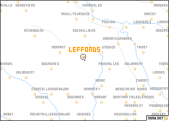
Leffonds (Champagne-Ardenne, France)Leffonds is a town in the Champagne-Ardenne region of France. An overview map of the region around Leffonds is displayed below.
regional and 3d topo map of Leffonds, France ::
Leffonds airports ::
The nearest airport is DIJ - Dijon Longvic, located 77.8 km south of Leffonds.
Other airports nearby include EPL - Epinal Mirecourt (78.1 km north east), QYR - Troyes Barberey (94.3 km north west), DLE - Dole Tavaux (105.0 km south), ENC - Nancy Essey (112.8 km north east), Nearby towns ::
Villiers-sur-Suize (3.1km north east) //
Rochvilliers (5.6km north) //
Crenay (5.6km north) //
Mormant (4.2km north west) //
Faverolles (4.2km south east) //
Marac (6.1km south east) //
Ormancey (7.5km south) //
Bugnières (5.3km west) //
Marnay-sur-Marne (6.2km north east) //
Ternat (7.8km south) //
Foulain (8.3km north east) //
Courcelles-sur-Aujon (8.9km south west) //
[all distances 'as the bird flies' and approximate]  Places with similar names to Leffonds, France ::
// Lafnitz (AT)
// Leventići (BA)
// Leventići (BA)
// Levintsy (UA)
// La Ventosa (ES)
// Lovnitsa (RU)
// La Ventosa (MX)
// La Ventosa (MX)
// La Ventosa (MX)
// Liu-fen-tzu (TW)
Disclaimer :: Information on this page comes without warranty of any kind |
||
|
Where is Leffonds? Elevation and coordinates ::
Latitude (lat): 47°58'0"N Longitude (lon): 5°10'0"E
Elevation (approx.): 365m (map arrows pan, magnifying glasses zoom) |
||
|
Visiting Leffonds? Hotel/Accommodation ::
Book a hotel in Leffonds Travel Guide ::
Buy a travel guide for France rental cars ::
car rental offers GPS waypoint ::
download a GPX waypoint (PoI) of Leffonds for your GPS receiver
|
||