|
search place name
|
||
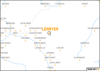
Le Mayem (Rhône-Alpes, France)Le Mayem is a town in the Rhône-Alpes region of France. An overview map of the region around Le Mayem is displayed below.
regional and 3d topo map of Le Mayem, France ::
Le Mayem airports ::
The nearest airport is NCY - Annecy Meythet, located 72.5 km north west of Le Mayem.
Other airports nearby include TRN - Torino (73.7 km south east), SIR - Sion (74.2 km north east), CMF - Chambery Aix Les Bains (80.9 km west), QNJ - Annemasse (81.4 km north west), Nearby towns ::
Les Masures (3.2km south west) //
Le Miroir (3.2km south west) //
Montalbert (4.5km south west) //
Le Villard (4.5km south west) //
Sainte-Foy-Tarentaise (4.5km south west) //
Le Châtelard (3.9km west) //
Les Eucherts (4.3km north west) //
Le Plan (6.1km south east) //
Le Planey (5.4km south west) //
Le Pré (5.4km south west) //
Villaroger (5.4km south west) //
La Thuille (6.1km south west) //
Le Monal (7.4km south) //
Chenal (7.4km south) //
La Rosière (5.5km west) //
La Gurra (7.5km south) //
[all distances 'as the bird flies' and approximate] 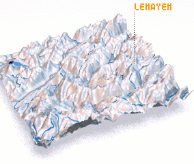
Disclaimer :: Information on this page comes without warranty of any kind |
||
|
Where is Le Mayem? Elevation and coordinates ::
Latitude (lat): 45°37'0"N Longitude (lon): 6°55'0"E
Elevation (approx.): 1721m (map arrows pan, magnifying glasses zoom) |
||
|
Visiting Le Mayem? Hotel/Accommodation ::
Book a hotel in Le Mayem Travel Guide ::
Buy a travel guide for France rental cars ::
car rental offers GPS waypoint ::
download a GPX waypoint (PoI) of Le Mayem for your GPS receiver
|
||