|
search place name
|
||
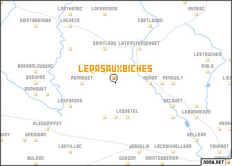
Le Pas aux Biches (Bretagne, France)Le Pas aux Biches is a town in the Bretagne region of France. An overview map of the region around Le Pas aux Biches is displayed below.
regional and 3d topo map of Le Pas aux Biches, France ::
Le Pas aux Biches airports ::
The nearest airport is VNE - Vannes Meucon, located 37.7 km south of Le Pas aux Biches.
Other airports nearby include SBK - St.-brieuc Armor Armor (57.8 km north), RNS - Rennes St Jacques (63.3 km east), DNR - Dinard Pleurtuit (70.5 km north east), LRT - Lorient Lann Bihoue (71.7 km south west), Nearby towns ::
Gastrie (2.2km north west) //
Le Cambout (3.1km north west) //
Bogas (5.6km south) //
Lanouée (5.6km south) //
Penhouët (3.7km west) //
Mohon (3.7km east) //
Le Quetel (5.7km south) //
Guillerien (5.7km south) //
Saint-Leau (5.7km north) //
Plumieux (5.7km north) //
La Trinité-Porhoët (6.1km north east) //
Bodieu (5.0km east) //
Les Forges (6.2km south west) //
Saint-Étienne-du-Gué-de-lʼIsle (7.4km north west) //
[all distances 'as the bird flies' and approximate]  Places with similar names to Le Pas aux Biches, France :: Disclaimer :: Information on this page comes without warranty of any kind |
||
|
Where is Le Pas aux Biches? Elevation and coordinates ::
Latitude (lat): 48°3'0"N Longitude (lon): 2°35'0"W
Elevation (approx.): 98m (map arrows pan, magnifying glasses zoom) |
||
|
Visiting Le Pas aux Biches? Hotel/Accommodation ::
Book a hotel in Le Pas aux Biches Travel Guide ::
Buy a travel guide for France rental cars ::
car rental offers GPS waypoint ::
download a GPX waypoint (PoI) of Le Pas aux Biches for your GPS receiver
|
||