|
search place name
|
||
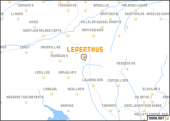
Le Perthus (Languedoc-Roussillon, France)Le Perthus is a town in the Languedoc-Roussillon region of France. An overview map of the region around Le Perthus is displayed below.
regional and 3d topo map of Le Perthus, France ::
Le Perthus airports ::
The nearest airport is PGF - Perpignan Rivesaltes, located 30.4 km north of Le Perthus.
Other airports nearby include GRO - Gerona Girona (63.4 km south), CCF - Carcassonne Salvaza (95.0 km north west), BZR - Beziers Vias (103.2 km north), LEU - Seo De Urgel (120.8 km west), Nearby towns ::
LʼÉcluse (2.3km north west) //
LʼAlbère (3.3km north east) //
San Julián (4.6km south west) //
Riunoguès (4.1km west) //
La Junquera (5.7km south) //
Montesquieu (5.7km north) //
Le Boulou (6.2km north west) //
Maureillas (5.8km west) //
Agullana (7.5km south) //
Villelongue-dels-Monts (7.9km north) //
Cantallops (7.8km south east) //
Laroque-des-Albères (7.8km north east) //
La Bajol (9.2km south west) //
[all distances 'as the bird flies' and approximate] 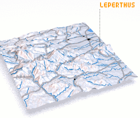 Places with similar names to Le Perthus, France :: Disclaimer :: Information on this page comes without warranty of any kind |
||
|
Where is Le Perthus? Elevation and coordinates ::
Latitude (lat): 42°28'0"N Longitude (lon): 2°52'0"E
Elevation (approx.): 342m (map arrows pan, magnifying glasses zoom) |
||
|
Visiting Le Perthus? Hotel/Accommodation ::
Book a hotel in Le Perthus Travel Guide ::
Buy a travel guide for France rental cars ::
car rental offers GPS waypoint ::
download a GPX waypoint (PoI) of Le Perthus for your GPS receiver
|
||