|
search place name
|
||
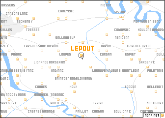
Le Pout (Aquitaine, France)Le Pout is a town in the Aquitaine region of France. An overview map of the region around Le Pout is displayed below.
regional and 3d topo map of Le Pout, France ::
Le Pout airports ::
The nearest airport is BOD - Bordeaux Merignac, located 27.8 km west of Le Pout.
Other airports nearby include XAC - Arcachon La Teste De Buch (63.2 km west), EGC - Bergerac Roumaniere (70.1 km east), CNG - Cognac Chateaubernard (95.5 km north), AGF - Agen La Garenne (103.1 km south east), Nearby towns ::
Créon (2.3km south east) //
Loupes (2.6km west) //
Camarsac (3.7km north) //
Croignon (3.2km north east) //
Salleboeuf (4.5km north west) //
Cursan (3.9km east) //
Saint-Genès-de-Lombaud (5.7km south) //
Sadirac (4.4km south west) //
Bonnetan (4.4km north west) //
Baron (4.4km north east) //
Madirac (5.4km south west) //
La Sauve-Majeure (5.4km south east) //
Lignan-de-Bordeaux (5.6km west) //
Haux (7.5km south) //
Saint-Germain-du-Puch (6.8km north east) //
Pompignac (7.7km north west) //
[all distances 'as the bird flies' and approximate]  Places with similar names to Le Pout, France ::
Disclaimer :: Information on this page comes without warranty of any kind |
||
|
Where is Le Pout? Elevation and coordinates ::
Latitude (lat): 44°48'0"N Longitude (lon): 0°22'0"W
Elevation (approx.): 72m (map arrows pan, magnifying glasses zoom) |
||
|
Visiting Le Pout? Hotel/Accommodation ::
Book a hotel in Le Pout Travel Guide ::
Buy a travel guide for France rental cars ::
car rental offers GPS waypoint ::
download a GPX waypoint (PoI) of Le Pout for your GPS receiver
|
||