|
search place name
|
||
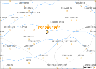
Les Bruyères (Centre, France)Les Bruyères is a town in the Centre region of France. An overview map of the region around Les Bruyères is displayed below.
regional and 3d topo map of Les Bruyères, France ::
Les Bruyères airports ::
The nearest airport is BOU - Bourges, located 43.3 km south of Les Bruyères.
Other airports nearby include ORE - Orleans Bricy (70.5 km north west), CHR - Chateauroux Deols (73.4 km south west), NVS - Nevers Fourchambault (83.1 km south east), AUF - Auxerre Branches (106.8 km north east), Nearby towns ::
Many (2.2km north east) //
La Guaiserie (3.7km north) //
Maisonneau (4.5km south east) //
Les Bergeries (4.5km north east) //
Souesmes (4.2km north west) //
Les Tannières (5.3km south west) //
Chassignol (5.3km west) //
Le Monnay (7.5km south west) //
Pierrefitte-sur-Sauldre (8.9km north west) //
[all distances 'as the bird flies' and approximate]  Places with similar names to Les Bruyères, France ::
// Les Bruyères (FR)
// Les Bruyères (FR)
// Les Bruyères (FR)
// Les Bruyères (FR)
// Les Bruyères (FR)
// Les Bruyères (FR)
// Les Bruyères (FR)
// Les Bruyères (FR)
// Les Bruyères (FR)
// Les Bruyères (FR)
Disclaimer :: Information on this page comes without warranty of any kind |
||
|
Where is Les Bruyères? Elevation and coordinates ::
Latitude (lat): 47°26'0"N Longitude (lon): 2°13'0"E
Elevation (approx.): 147m (map arrows pan, magnifying glasses zoom) |
||
|
Visiting Les Bruyères? Hotel/Accommodation ::
Book a hotel in Les Bruyères Travel Guide ::
Buy a travel guide for France rental cars ::
car rental offers GPS waypoint ::
download a GPX waypoint (PoI) of Les Bruyères for your GPS receiver
|
||