|
search place name
|
||
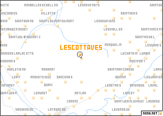
Les Cottaves (Rhône-Alpes, France)Les Cottaves is a town in the Rhône-Alpes region of France. An overview map of the region around Les Cottaves is displayed below.
regional and 3d topo map of Les Cottaves, France ::
Les Cottaves airports ::
The nearest airport is GNB - Grenoble Saint Geoirs, located 36.0 km west of Les Cottaves.
Other airports nearby include CMF - Chambery Aix Les Bains (36.5 km north), LYS - Lyon Saint Exupery (70.7 km north west), NCY - Annecy Meythet (72.4 km north), VAF - Valence Chabeuil (77.6 km south west), Nearby towns ::
Cherlieu (0.0km north) //
Saint-Pierre-de-Chartreuse (3.2km north east) //
Le Sappey-en-Chartreuse (5.6km south) //
Sarcenas (6.1km south west) //
Perquelin (5.5km east) //
Le Massot (6.8km north east) //
Pomaray (6.4km south west) //
Le Milliet (7.9km south) //
Les Meuniers (8.4km north east) //
Saint-Laurent-du-Pont (8.4km north west) //
Saint-Ismier (8.4km south east) //
Les Vialles (7.6km north east) //
Quaix (9.1km south west) //
Les Eymes (9.1km south east) //
[all distances 'as the bird flies' and approximate] 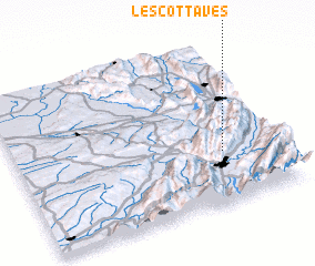 Places with similar names to Les Cottaves, France ::
// Los Cautivos (MX)
// Les Chétifs (FR)
Disclaimer :: Information on this page comes without warranty of any kind |
||
|
Where is Les Cottaves? Elevation and coordinates ::
Latitude (lat): 45°19'0"N Longitude (lon): 5°47'0"E
Elevation (approx.): 1001m (map arrows pan, magnifying glasses zoom) |
||
|
Visiting Les Cottaves? Hotel/Accommodation ::
Book a hotel in Les Cottaves Travel Guide ::
Buy a travel guide for France rental cars ::
car rental offers GPS waypoint ::
download a GPX waypoint (PoI) of Les Cottaves for your GPS receiver
|
||