|
search place name
|
||
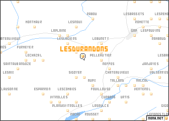
Les Durandons (Provence-Alpes-Côte dʼAzur, France)Les Durandons is a town in the Provence-Alpes-Côte dʼAzur region of France. An overview map of the region around Les Durandons is displayed below.
regional and 3d topo map of Les Durandons, France ::
Les Durandons airports ::
The nearest airport is VAF - Valence Chabeuil, located 92.0 km north west of Les Durandons.
Other airports nearby include GNB - Grenoble Saint Geoirs (107.3 km north west), AVN - Avignon Caumont (109.8 km south west), QXB - Aix-les-milles Aix Les Milles (122.7 km south west), CMF - Chambery Aix Les Bains (124.9 km north), Nearby towns ::
Manteyer (2.3km north west) //
Pelleautier (2.6km east) //
Les Courtes (3.7km south) //
La Freissinouse (3.2km north east) //
Sigoyer (3.9km south) //
Les Lagiers (4.6km north west) //
Le Burety (4.6km north east) //
Neffes (4.4km south east) //
Aupx (5.7km south) //
La Roche-des-Arnauds (6.2km north west) //
Les Roux (7.5km north) //
La Plaine (6.8km north west) //
Les Combes (7.9km south) //
Fouillouse (7.9km south) //
Châteauvieux (6.5km south east) //
Tallard (7.7km south east) //
[all distances 'as the bird flies' and approximate] 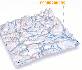 Places with similar names to Les Durandons, France :: Disclaimer :: Information on this page comes without warranty of any kind |
||
|
Where is Les Durandons? Elevation and coordinates ::
Latitude (lat): 44°31'0"N Longitude (lon): 5°59'0"E
Elevation (approx.): 1147m (map arrows pan, magnifying glasses zoom) |
||
|
Visiting Les Durandons? Hotel/Accommodation ::
Book a hotel in Les Durandons Travel Guide ::
Buy a travel guide for France rental cars ::
car rental offers GPS waypoint ::
download a GPX waypoint (PoI) of Les Durandons for your GPS receiver
|
||