|
search place name
|
||
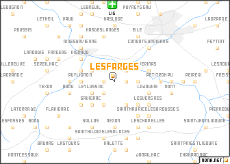
Les Farges (Limousin, France)Les Farges is a town in the Limousin region of France. An overview map of the region around Les Farges is displayed below.
regional and 3d topo map of Les Farges, France ::
Les Farges airports ::
The nearest airport is LIG - Limoges Bellegarde, located 12.5 km north of Les Farges.
Other airports nearby include PGX - Perigueux Bassillac (67.7 km south west), BVE - Brive La Roche (70.2 km south), ANG - Angouleme Brie Champniers (74.9 km west), MCU - Montlucon-gueret Montlucon Gueret (105.5 km north east), Nearby towns ::
Nouailhas (1.3km west) //
Bosmie (1.3km east) //
Grand Chalier (2.3km south west) //
La Frugerie (2.3km north east) //
Envaud (2.6km east) //
Banneix (2.6km east) //
La Côte (3.9km south) //
Ley-Lussac (3.2km south west) //
Beynac (3.2km north west) //
Jourgnac (3.9km south) //
Burgnac (4.5km south west) //
Meilhac (4.5km south west) //
Savignac (4.5km south west) //
Le Grand Village (4.5km south east) //
Puylignon (3.9km west) //
Le Breuil (4.3km north west) //
La Jauvie (4.3km south east) //
Verinas (4.3km north east) //
Vignaud (5.4km north west) //
Lavignac (5.4km south west) //
Le Puytren (5.4km south west) //
Les Vergnes (5.4km south east) //
Triquerie (6.1km south east) //
Saint-Martin-le-Vieux (5.2km west) //
Nexon (7.4km south) //
Petit Rompu (5.2km east) //
Bord (5.5km west) //
Mas des Landes (7.5km north) //
Aixe-sur-Vienne (6.8km north west) //
[all distances 'as the bird flies' and approximate]  Places with similar names to Les Farges, France ::
// Les Forges (FR)
// Les Forges (FR)
// Les Forges (FR)
// Les Farges (FR)
// Les Farges (FR)
// Les Farges (FR)
// Les Farges (FR)
// Les Farges (FR)
// Les Forges (FR)
// Les Forges (FR)
Disclaimer :: Information on this page comes without warranty of any kind |
||
|
Where is Les Farges? Elevation and coordinates ::
Latitude (lat): 45°45'0"N Longitude (lon): 1°11'0"E
Elevation (approx.): 284m (map arrows pan, magnifying glasses zoom) |
||
|
Visiting Les Farges? Hotel/Accommodation ::
Book a hotel in Les Farges Travel Guide ::
Buy a travel guide for France rental cars ::
car rental offers GPS waypoint ::
download a GPX waypoint (PoI) of Les Farges for your GPS receiver
|
||