|
search place name
|
||
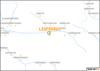
Les Fréaux (Provence-Alpes-Côte dʼAzur, France)Les Fréaux is a town in the Provence-Alpes-Côte dʼAzur region of France. An overview map of the region around Les Fréaux is displayed below.
regional and 3d topo map of Les Fréaux, France ::
Les Fréaux airports ::
The nearest airport is CMF - Chambery Aix Les Bains, located 74.3 km north west of Les Fréaux.
Other airports nearby include GNB - Grenoble Saint Geoirs (83.4 km north west), NCY - Annecy Meythet (100.6 km north), VAF - Valence Chabeuil (104.3 km west), TRN - Torino (109.1 km east), Nearby towns ::
Le Chazelet (1.9km north) //
La Grave (2.3km north east) //
Rivet du Milieu (3.7km north) //
Les Hières (3.2km north east) //
Les Vernois (3.2km north east) //
Villar-dʼArène (3.9km east) //
Pramélier (5.4km north east) //
La Buffe (7.9km north) //
[all distances 'as the bird flies' and approximate] 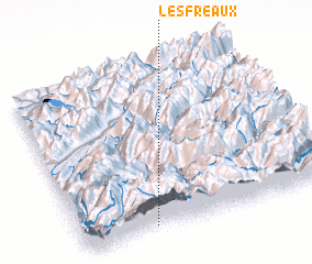 Places with similar names to Les Fréaux, France ::
// Las Fraguas (ES)
// Las Fraguas (ES)
// Los Vargas (ES)
// Los Vargas (CO)
// Les Fourgs (FR)
// Les Fargues (FR)
// Les Fargues (FR)
// Les Froux (FR)
// Les Vauroux (FR)
Disclaimer :: Information on this page comes without warranty of any kind |
||
|
Where is Les Fréaux? Elevation and coordinates ::
Latitude (lat): 45°2'0"N Longitude (lon): 6°17'0"E
Elevation (approx.): 2063m (map arrows pan, magnifying glasses zoom) |
||
|
Visiting Les Fréaux? Hotel/Accommodation ::
Book a hotel in Les Fréaux Travel Guide ::
Buy a travel guide for France rental cars ::
car rental offers GPS waypoint ::
download a GPX waypoint (PoI) of Les Fréaux for your GPS receiver
|
||