|
search place name
|
||
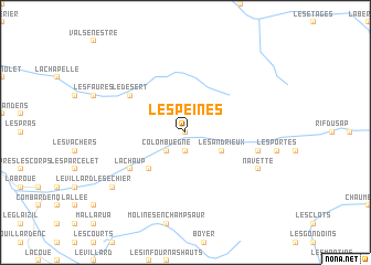
Les Peines (Provence-Alpes-Côte dʼAzur, France)Les Peines is a town in the Provence-Alpes-Côte dʼAzur region of France. An overview map of the region around Les Peines is displayed below.
regional and 3d topo map of Les Peines, France ::
Les Peines airports ::
The nearest airport is GNB - Grenoble Saint Geoirs, located 86.4 km north west of Les Peines.
Other airports nearby include CMF - Chambery Aix Les Bains (91.6 km north), VAF - Valence Chabeuil (92.4 km west), NCY - Annecy Meythet (121.8 km north), CUF - Levaldigi (122.3 km east), Nearby towns ::
Villar-Loubière (0.0km north) //
La Loubière (1.9km south) //
Le Roux (2.3km south west) //
Colombuègne (2.3km south west) //
Les Andrieux (3.2km south east) //
LʼUbac (4.5km south west) //
Saint-Maurice-en-Valgodemard (5.4km south west) //
Lachaup (5.4km south west) //
Le Désert (5.4km north west) //
Le Chaussendent (5.6km east) //
La Chapelle-en-Valgodemard (5.6km east) //
Fouronnière (6.4km south east) //
Navette (6.4km south east) //
Le Séchier (7.7km south west) //
[all distances 'as the bird flies' and approximate]  Places with similar names to Les Peines, France ::
Disclaimer :: Information on this page comes without warranty of any kind |
||
|
Where is Les Peines? Elevation and coordinates ::
Latitude (lat): 44°50'0"N Longitude (lon): 6°8'0"E
Elevation (approx.): 1574m (map arrows pan, magnifying glasses zoom) |
||
|
Visiting Les Peines? Hotel/Accommodation ::
Book a hotel in Les Peines Travel Guide ::
Buy a travel guide for France rental cars ::
car rental offers GPS waypoint ::
download a GPX waypoint (PoI) of Les Peines for your GPS receiver
|
||