|
search place name
|
||
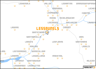
Les Saurels (Provence-Alpes-Côte dʼAzur, France)Les Saurels is a town in the Provence-Alpes-Côte dʼAzur region of France. An overview map of the region around Les Saurels is displayed below.
regional and 3d topo map of Les Saurels, France ::
Les Saurels airports ::
The nearest airport is CUF - Levaldigi, located 84.4 km east of Les Saurels.
Other airports nearby include TRN - Torino (106.2 km north east), NCE - Nice Cote D Azur (120.1 km south east), CMF - Chambery Aix Les Bains (124.0 km north west), CEQ - Cannes Mandelieu (125.2 km south), Nearby towns ::
Serre-Busard (1.3km west) //
Les Clots (1.9km north) //
Siguret (2.3km south west) //
Saint-Clément (2.3km north east) //
Saint-Étienne (2.6km west) //
Barbein (3.2km north east) //
Les Casses (3.9km north) //
Les Florins (4.5km south east) //
Réotier (4.5km north east) //
Saint-Marcellin (4.4km south west) //
Châteauroux (4.4km south west) //
Mikeou (5.7km north) //
Gaudissart (4.4km north east) //
Doussarelle (4.4km north east) //
Les Rencuraux (6.2km south west) //
Saint-André-dʼEmbrun (6.2km south west) //
Mont-Dauphin (5.4km north east) //
Le Ponteil (7.4km north) //
Le Villard (7.5km south) //
Risoul (5.6km east) //
Chauvet (5.6km east) //
Les Pasques (7.5km north) //
Chanteloube (7.5km north) //
Pralong (6.8km south west) //
Serre Collomp (7.9km south) //
Les Clots (7.9km south) //
Eygliers (6.4km north east) //
La Reste (6.4km south west) //
Les Achards (7.9km north) //
[all distances 'as the bird flies' and approximate]  Places with similar names to Les Saurels, France ::
// Los Cerrillos (PA)
// Las Erillas (ES)
// Las Orillas (ES)
// Los Cerrillos (ES)
// Los Cerrilos (US)
// Los Cerrillos (CL)
// Los Cerrillos (CL)
// Los Ciruelos (CL)
// Los Raulíes (CL)
// Los Rulos (CL)
Disclaimer :: Information on this page comes without warranty of any kind |
||
|
Where is Les Saurels? Elevation and coordinates ::
Latitude (lat): 44°38'0"N Longitude (lon): 6°34'0"E
Elevation (approx.): 869m (map arrows pan, magnifying glasses zoom) |
||
|
Visiting Les Saurels? Hotel/Accommodation ::
Book a hotel in Les Saurels Travel Guide ::
Buy a travel guide for France rental cars ::
car rental offers GPS waypoint ::
download a GPX waypoint (PoI) of Les Saurels for your GPS receiver
|
||