|
search place name
|
||
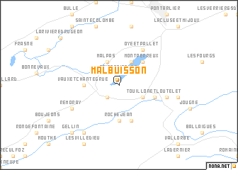
Malbuisson (Franche-Comté, France)Malbuisson is a town in the Franche-Comté region of France. An overview map of the region around Malbuisson is displayed below.
regional and 3d topo map of Malbuisson, France ::
Malbuisson airports ::
The nearest airport is GVA - Geneva Cointrin, located 64.2 km south of Malbuisson.
Other airports nearby include QNJ - Annemasse (67.6 km south), DLE - Dole Tavaux (71.6 km west), BRN - Bern Belp (92.2 km east), NCY - Annecy Meythet (98.0 km south), Nearby towns ::
Saint-Point-Lac (1.9km north) //
Granges-Sainte-Marie (2.2km south west) //
Labergement-Sainte-Marie (2.2km south west) //
Saint-Antoine (3.1km south east) //
Malpas (3.9km north) //
La Planée (3.9km north) //
Les Grangettes (3.9km north) //
Montperreux (4.5km north east) //
Rochejean (5.6km south) //
Vaux-et-Chantegrue (3.8km west) //
Longevilles-Mont-dʼOr (5.7km south) //
Touillon-et-Loutelet (4.2km south east) //
Métabief (4.2km south east) //
Oye-et-Pallet (6.1km north east) //
Les Hôpitaux-Vieux (5.4km east) //
Remoray (6.3km south west) //
Brey-et-Maison-du-Bois (8.3km south west) //
Gellin (9.0km south west) //
[all distances 'as the bird flies' and approximate] 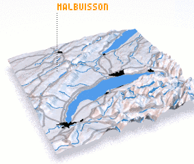 Places with similar names to Malbuisson, France ::
Disclaimer :: Information on this page comes without warranty of any kind |
||
|
Where is Malbuisson? Elevation and coordinates ::
Latitude (lat): 46°48'0"N Longitude (lon): 6°18'0"E
Elevation (approx.): 848m (map arrows pan, magnifying glasses zoom) |
||
|
Visiting Malbuisson? Hotel/Accommodation ::
Book a hotel in Malbuisson Travel Guide ::
Buy a travel guide for France rental cars ::
car rental offers GPS waypoint ::
download a GPX waypoint (PoI) of Malbuisson for your GPS receiver
|
||