|
search place name
|
||
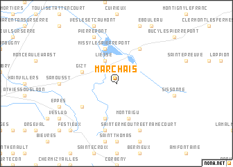
Marchais (Picardie, France)Marchais is a town in the Picardie region of France. An overview map of the region around Marchais is displayed below.
regional and 3d topo map of Marchais, France ::
Marchais airports ::
The nearest airport is RHE - Reims Champagne, located 34.8 km south east of Marchais.
Other airports nearby include CSF - Creil (101.0 km west), CRL - Charleroi Brussels South (107.6 km north east), CDG - Paris Charles De Gaulle (111.9 km south west), LIL - Lille Lesquin (120.7 km north west), Nearby towns ::
Liesse (3.9km north) //
Montaigu (5.7km south) //
Missy-lès-Pierrepont (5.7km north) //
Mauregny-en-Haye (5.7km south) //
Gizy (4.1km north west) //
Chivres-en-Laonnois (6.1km north east) //
Coucy-lès-Eppes (5.2km south west) //
Courtrizy-et-Fussigny (7.5km south) //
Saint-Erme-Outre-et-Ramecourt (7.8km south) //
Pierrepont (7.8km north) //
Festieux (8.8km south west) //
[all distances 'as the bird flies' and approximate] 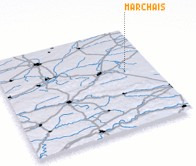 Places with similar names to Marchais, France ::
Disclaimer :: Information on this page comes without warranty of any kind |
||
|
Where is Marchais? Elevation and coordinates ::
Latitude (lat): 49°35'0"N Longitude (lon): 3°49'0"E
Elevation (approx.): 77m (map arrows pan, magnifying glasses zoom) |
||
|
Visiting Marchais? Hotel/Accommodation ::
Book a hotel in Marchais Travel Guide ::
Buy a travel guide for France rental cars ::
car rental offers GPS waypoint ::
download a GPX waypoint (PoI) of Marchais for your GPS receiver
|
||