|
search place name
|
||
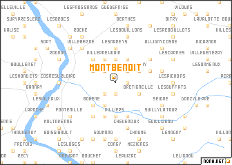
Mont-Benoît (Bourgogne, France)Mont-Benoît is a town in the Bourgogne region of France. An overview map of the region around Mont-Benoît is displayed below.
regional and 3d topo map of Mont-Benoît, France ::
Mont-Benoît airports ::
The nearest airport is NVS - Nevers Fourchambault, located 45.0 km south of Mont-Benoît.
Other airports nearby include BOU - Bourges (61.0 km south west), AUF - Auxerre Branches (62.5 km north east), XMU - Moulins Montbeugny (101.5 km south), CHR - Chateauroux Deols (113.4 km south west), Nearby towns ::
Chambre (1.3km east) //
Pougny (1.9km south) //
Villemoison (2.2km north west) //
Ménétereau (2.2km south west) //
Villaine (2.2km north east) //
Bas Évry (3.7km north) //
Saint-Martin-sur-Nohain (3.9km south) //
Parigny (3.1km north east) //
Saint-Père (3.1km north west) //
Brétignelle (3.1km south east) //
Haut Évry (3.9km north) //
Villepreuvoir (3.9km north) //
Bohème (4.5km south west) //
Cours (4.5km north west) //
Villiers (5.6km south) //
Saint-Loup (5.6km north) //
Les Nareys (5.6km north) //
Saint-Quentin-sur Nohain (5.7km south) //
Saint-Laurent-lʼAbbaye (5.7km south) //
Meung (4.2km north east) //
Moussard (6.1km south west) //
Les Breuillards (6.1km south west) //
La Brosse-aux-Brins (5.3km north east) //
Les Bouillons (7.5km north) //
Cheveroux (7.5km south) //
La Grande Brosse (5.3km east) //
Villeberne (6.7km north west) //
Seigne (6.2km south east) //
Suilly-la-Tour (7.5km south east) //
[all distances 'as the bird flies' and approximate]  Places with similar names to Mont-Benoît, France ::
// Monte Bonito (CU)
// Montebonito (CO)
// Monte Bonito (MX)
// Monte Bonito (MX)
// Miāndi Bāndi (PK)
// Monte Bonito (VE)
// Montbenoît (FR)
// Monte Bonito (DO)
// Monte Bonito (DO)
// Monte Bonito (DO)
Disclaimer :: Information on this page comes without warranty of any kind |
||
|
Where is Mont-Benoît? Elevation and coordinates ::
Latitude (lat): 47°24'0"N Longitude (lon): 3°0'0"E
Elevation (approx.): 227m (map arrows pan, magnifying glasses zoom) |
||
|
Visiting Mont-Benoît? Hotel/Accommodation ::
Book a hotel in Mont-Benoît Travel Guide ::
Buy a travel guide for France rental cars ::
car rental offers GPS waypoint ::
download a GPX waypoint (PoI) of Mont-Benoît for your GPS receiver
|
||