|
search place name
|
||
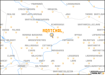
Montchal (Rhône-Alpes, France)Montchal is a town in the Rhône-Alpes region of France. An overview map of the region around Montchal is displayed below.
regional and 3d topo map of Montchal, France ::
Montchal airports ::
The nearest airport is XVF - Vilefrance Tarare, located 25.9 km east of Montchal.
Other airports nearby include EBU - St.-etienne Boutheon (32.6 km south), RNE - Roanne Renaison (35.0 km north west), LYN - Lyon Bron (50.2 km east), LYS - Lyon Saint Exupery (61.4 km east), Nearby towns ::
Sainte-Agathe-en-Donzy (0.0km north) //
Fontanne (1.3km east) //
Montmain (2.3km north west) //
Violay (3.2km north east) //
Cottance (3.9km south) //
Échanssieux (3.9km north) //
Rozier-en-Donzy (4.5km south west) //
Bussières (3.9km west) //
Panissières (5.7km south) //
Basses Fenêtres (4.3km south west) //
Fontbonne (4.3km south east) //
Sainte-Colombe-sur-Gand (6.8km north west) //
Paillassieux (6.4km south west) //
Salvizinet (8.4km south west) //
Chambost-Longessaigne (8.4km south east) //
Civens (7.6km south west) //
Joux (8.4km north east) //
Les Gorges (9.0km south east) //
Saint-Just-la-Pendue (9.0km north west) //
[all distances 'as the bird flies' and approximate] 
Disclaimer :: Information on this page comes without warranty of any kind |
||
|
Where is Montchal? Elevation and coordinates ::
Latitude (lat): 45°50'0"N Longitude (lon): 4°19'0"E
Elevation (approx.): 673m (map arrows pan, magnifying glasses zoom) |
||
|
Visiting Montchal? Hotel/Accommodation ::
Book a hotel in Montchal Travel Guide ::
Buy a travel guide for France rental cars ::
car rental offers GPS waypoint ::
download a GPX waypoint (PoI) of Montchal for your GPS receiver
|
||