|
search place name
|
||
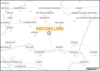
Montgaillard (Languedoc-Roussillon, France)Montgaillard is a town in the Languedoc-Roussillon region of France. An overview map of the region around Montgaillard is displayed below.
regional and 3d topo map of Montgaillard, France ::
Montgaillard airports ::
The nearest airport is PGF - Perpignan Rivesaltes, located 27.6 km south east of Montgaillard.
Other airports nearby include CCF - Carcassonne Salvaza (42.6 km north west), BZR - Beziers Vias (74.0 km north east), DCM - Castres Mazamet (76.4 km north), GRO - Gerona Girona (113.3 km south), Nearby towns ::
Maisons (1.9km north) //
Dernacueillette (3.3km north west) //
Palairac (4.6km north east) //
Massac (4.1km west) //
Davejean (5.7km north) //
Padern (6.2km south east) //
Félines-Termenès (7.5km north) //
Laroque-de-Fa (6.6km north west) //
Cucugnan (7.9km south) //
Duilhac (7.8km south west) //
[all distances 'as the bird flies' and approximate] 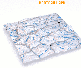 Places with similar names to Montgaillard, France ::
// Montclard (FR)
// Montgaillard (FR)
// Montgaillard (FR)
// Montgaillard (FR)
// Montgaillard (FR)
// Montgaillard (FR)
Disclaimer :: Information on this page comes without warranty of any kind |
||
|
Where is Montgaillard? Elevation and coordinates ::
Latitude (lat): 42°55'0"N Longitude (lon): 2°38'0"E
Elevation (approx.): 350m (map arrows pan, magnifying glasses zoom) |
||
|
Visiting Montgaillard? Hotel/Accommodation ::
Book a hotel in Montgaillard Travel Guide ::
Buy a travel guide for France rental cars ::
car rental offers GPS waypoint ::
download a GPX waypoint (PoI) of Montgaillard for your GPS receiver
|
||