|
search place name
|
||
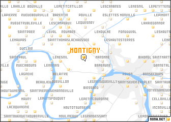
Montigny (Haute-Normandie, France)Montigny is a town in the Haute-Normandie region of France. An overview map of the region around Montigny is displayed below.
regional and 3d topo map of Montigny, France ::
Montigny airports ::
The nearest airport is URO - Rouen Vallee De Seine, located 15.7 km south east of Montigny.
Other airports nearby include DOL - Deauville St Gatien (62.4 km west), LEH - Le Havre Octeville (66.5 km west), BVA - Beauvais Tille (80.7 km east), POX - Pontoise Cormeilles En Vexin (86.2 km south east), Nearby towns ::
La Vaupalière (2.2km north east) //
Maromme (2.4km east) //
Déville-lès-Rouen (2.4km east) //
Haut de lʼOuraille (3.0km north west) //
Hénouville (3.0km north west) //
Saint-Martin-de-Boscherville (3.0km south west) //
Canteleu (3.0km south east) //
Bapeaume (3.0km south east) //
Saint-Jean-du-Cardonnay (3.9km north) //
Dieppedalle (3.9km south) //
Croisset (4.1km south east) //
Saint-Thomas-la-Chaussée (4.4km north west) //
Le Petit-Quevilly (4.4km south east) //
Le Mesnil (3.6km west) //
Notre-Dame-de-Bondeville (4.1km north east) //
Le Grand-Quevilly (6.1km south east) //
Roumare (6.1km north west) //
Le Houlme (6.1km north east) //
Belaitre (5.2km south west) //
Biessard (6.8km south) //
Pissy-Pôville (7.4km north) //
Le Quesnay (7.4km north) //
Ambourville (4.8km west) //
Le Marais (5.2km west) //
Quenneport (7.5km south) //
Quevillon (6.6km south west) //
Candos (6.6km north west) //
Malaunay (7.8km north) //
Le Mesnil-Roux (7.8km north) //
[all distances 'as the bird flies' and approximate] 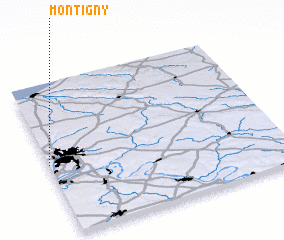 Places with similar names to Montigny, France ::
Disclaimer :: Information on this page comes without warranty of any kind |
||
|
Where is Montigny? Elevation and coordinates ::
Latitude (lat): 49°28'0"N Longitude (lon): 1°0'0"E
Elevation (approx.): 130m (map arrows pan, magnifying glasses zoom) |
||
|
Visiting Montigny? Hotel/Accommodation ::
Book a hotel in Montigny Travel Guide ::
Buy a travel guide for France rental cars ::
car rental offers GPS waypoint ::
download a GPX waypoint (PoI) of Montigny for your GPS receiver
|
||