|
search place name
|
||
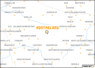
Montmelard (Bourgogne, France)Montmelard is a town in the Bourgogne region of France. An overview map of the region around Montmelard is displayed below.
regional and 3d topo map of Montmelard, France ::
Montmelard airports ::
The nearest airport is QNX - Macon Charnay, located 29.5 km east of Montmelard.
Other airports nearby include RNE - Roanne Renaison (44.3 km south west), XVF - Vilefrance Tarare (50.8 km south), XCD - Chalon Champforgeuil (62.8 km north east), XBK - Bourg Ceyzeriat (69.1 km east), Nearby towns ::
Gibles (3.2km south west) //
Aigueperse (5.7km south) //
Châtenay (6.1km south west) //
Dompierre-les-Ormes (5.4km east) //
Vérosvres (7.5km north) //
Bois-Sainte-Marie (5.4km west) //
Beaubery (7.5km north) //
Matour (6.3km south east) //
Saint-Bonnet-des-Bruyères (8.3km south east) //
Saint-Racho (8.3km south west) //
Ozolles (7.6km north west) //
[all distances 'as the bird flies' and approximate] 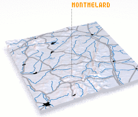 Places with similar names to Montmelard, France :: Disclaimer :: Information on this page comes without warranty of any kind |
||
|
Where is Montmelard? Elevation and coordinates ::
Latitude (lat): 46°20'0"N Longitude (lon): 4°25'0"E
Elevation (approx.): 462m (map arrows pan, magnifying glasses zoom) |
||
|
Visiting Montmelard? Hotel/Accommodation ::
Book a hotel in Montmelard Travel Guide ::
Buy a travel guide for France rental cars ::
car rental offers GPS waypoint ::
download a GPX waypoint (PoI) of Montmelard for your GPS receiver
|
||