|
search place name
|
||
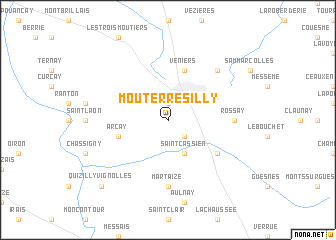
Mouterre-Silly (Poitou-Charentes, France)Mouterre-Silly is a town in the Poitou-Charentes region of France. An overview map of the region around Mouterre-Silly is displayed below.
regional and 3d topo map of Mouterre-Silly, France ::
Mouterre-Silly airports ::
The nearest airport is PIS - Poitiers Biard, located 47.6 km south east of Mouterre-Silly.
Other airports nearby include TUF - Tours Val De Loire (70.7 km north east), CET - Cholet Le Pontreau (72.6 km west), NIT - Niort Souche (82.9 km south west), LME - Le Mans Arnage (107.8 km north), Nearby towns ::
Loudun (1.9km north) //
Chalais (2.2km south east) //
Saint-Cassien (3.9km south) //
Arçay (4.2km south west) //
Véniers (5.7km north) //
Angliers (5.3km south east) //
Martaizé (7.4km south) //
Rossay (5.1km east) //
Basses (6.7km north east) //
Quizilly-Vignolles (9.0km south west) //
[all distances 'as the bird flies' and approximate]  Places with similar names to Mouterre-Silly, France ::
// Mittersill (AT)
// Mattierzoll (DE)
// Mittersill (US)
// Madre Sal (SV)
// Moutier-Rozeille (FR)
Disclaimer :: Information on this page comes without warranty of any kind |
||
|
Where is Mouterre-Silly? Elevation and coordinates ::
Latitude (lat): 46°59'0"N Longitude (lon): 0°4'0"W
Elevation (approx.): 85m (map arrows pan, magnifying glasses zoom) |
||
|
Visiting Mouterre-Silly? Hotel/Accommodation ::
Book a hotel in Mouterre-Silly Travel Guide ::
Buy a travel guide for France rental cars ::
car rental offers GPS waypoint ::
download a GPX waypoint (PoI) of Mouterre-Silly for your GPS receiver
|
||