|
search place name
|
||
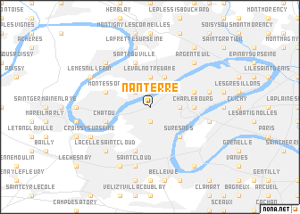
Nanterre (France)Nanterre is a town in France. An overview map of the region around Nanterre is displayed below.
regional and 3d topo map of Nanterre, France ::
nearby GPS traces from timatio ::
Nanterre airports ::
The nearest airport is TNF - Toussous-le-noble Toussus Le Noble, located 17.8 km south west of Nanterre.
Other airports nearby include LBG - Paris Le Bourget (19.3 km north east), ORY - Paris Orly (22.7 km south east), POX - Pontoise Cormeilles En Vexin (24.8 km north west), CDG - Paris Charles De Gaulle (28.5 km north east), Nearby towns ::
Rueil-Malmaison (1.9km south) //
Houilles (1.9km north) //
Carrières-sur-Seine (2.2km north west) //
La Défense (2.4km east) //
Le Val Notre-Dame (3.7km north) //
Bezons (3.9km north) //
Puteaux (4.4km south east) //
Suresnes (4.4km south east) //
Charlebourg (3.7km east) //
Courbevoic (3.7km east) //
La Garenne-Colombes (3.7km east) //
Garches (5.7km south) //
Colombes (4.1km north east) //
Montesson (4.1km north west) //
Chatou (4.1km south west) //
Sartrouville (5.7km north) //
Saint-Cloud (7.5km south) //
La Frette-sur-Seine (7.5km north) //
Bois-Colombes (5.2km east) //
Neuilly-sur-Seine (5.2km east) //
La Celle-Saint-Cloud (6.7km south west) //
Argenteuil (6.7km north east) //
Maisons-Laffitte (6.7km north west) //
Bougival (6.1km south west) //
Croissy-sur-Seine (6.1km south west) //
Vaucresson (7.8km south) //
Marnes-la-Coquette (7.8km south) //
Le Mesnil-le-Roi (6.1km north west) //
Sannois (8.3km north east) //
[all distances 'as the bird flies' and approximate] 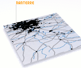 Places with similar names to Nanterre, France ::
Disclaimer :: Information on this page comes without warranty of any kind |
||
|
Where is Nanterre? Elevation and coordinates ::
Latitude (lat): 48°54'0"N Longitude (lon): 2°12'0"E
Elevation (approx.): 25m (map arrows pan, magnifying glasses zoom) |
||
|
Visiting Nanterre? Hotel/Accommodation ::
Book a hotel in Nanterre Travel Guide ::
Buy a travel guide for France rental cars ::
car rental offers GPS waypoint ::
download a GPX waypoint (PoI) of Nanterre for your GPS receiver
|
||