|
search place name
|
||
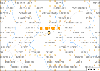
Oubissous (Auvergne, France)Oubissous is a town in the Auvergne region of France. An overview map of the region around Oubissous is displayed below.
regional and 3d topo map of Oubissous, France ::
Oubissous airports ::
The nearest airport is LPY - Le Puy Loudes, located 29.2 km south of Oubissous.
Other airports nearby include EBU - St.-etienne Boutheon (40.8 km north east), CFE - Clermont Ferrand Auvergne (74.2 km north west), RNE - Roanne Renaison (81.3 km north), XVF - Vilefrance Tarare (87.1 km north east), Nearby towns ::
Bougerne (1.9km south) //
Craponne-sur-Arzon (1.3km west) //
Ranchoux (1.9km north) //
Fraisse (2.3km south east) //
Vernet-Chabre (2.3km north west) //
Theux (2.6km east) //
La Fretisse (3.7km south) //
Ollias (2.6km west) //
Le Pinet (3.7km north) //
Piassac (3.2km south east) //
Saint-George-Lagricol (3.9km south) //
Doulioux (3.9km south) //
Sermoulis (3.9km north) //
Soulage (3.2km north west) //
Lissac (4.5km north east) //
Sauvessanges (5.6km north) //
Péret (3.9km east) //
Brandy (4.3km north east) //
Saint-Jean-dʼAubrigoux (4.3km north west) //
Trivis (4.3km north west) //
Les Terrasses (6.1km south east) //
Fresse Rival (6.1km north east) //
Saint-Julien-dʼAnce (5.4km south east) //
Triouleyre (5.4km north west) //
Sassac (7.4km south) //
Sauvessanelle (7.4km north) //
Doupis (5.2km west) //
Cheyrac (5.2km west) //
Pinet (7.5km south) //
[all distances 'as the bird flies' and approximate]  Places with similar names to Oubissous, France ::
// Obsza (PL)
Disclaimer :: Information on this page comes without warranty of any kind |
||
|
Where is Oubissous? Elevation and coordinates ::
Latitude (lat): 45°20'0"N Longitude (lon): 3°52'0"E
Elevation (approx.): 929m (map arrows pan, magnifying glasses zoom) |
||
|
Visiting Oubissous? Hotel/Accommodation ::
Book a hotel in Oubissous Travel Guide ::
Buy a travel guide for France rental cars ::
car rental offers GPS waypoint ::
download a GPX waypoint (PoI) of Oubissous for your GPS receiver
|
||