|
search place name
|
||
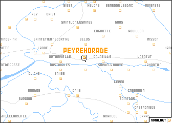
Peyrehorade (Aquitaine, France)Peyrehorade is a town in the Aquitaine region of France. An overview map of the region around Peyrehorade is displayed below.
regional and 3d topo map of Peyrehorade, France ::
Peyrehorade airports ::
The nearest airport is BIQ - Biarritz-bayonne Anglet, located 35.4 km west of Peyrehorade.
Other airports nearby include PUF - Pau Pyrenees (58.3 km east), EAS - San Sebastian (59.9 km west), PNA - Pamplona (97.4 km south west), LDE - Tarbes Lourdes (97.8 km south east), Nearby towns ::
Oeyregave (1.9km south) //
Cauneille (2.7km east) //
Bélus (3.7km north) //
Orthevielle (4.0km west) //
Hastingues (4.4km south west) //
Sorde-lʼAbbaye (4.4km south east) //
Sames (5.5km south west) //
Cagnotte (6.2km north east) //
Came (7.5km south) //
Saint-Lon-les-Mines (7.5km north) //
Bidache (7.9km south) //
Saint-Étienne-dʼOrthe (6.5km north west) //
Léren (7.7km south east) //
Saint-Pé-de-Léren (9.2km south east) //
Gaas (9.2km north east) //
[all distances 'as the bird flies' and approximate] 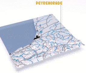 Places with similar names to Peyrehorade, France ::
// Pīr Harāt (IR)
Disclaimer :: Information on this page comes without warranty of any kind |
||
|
Where is Peyrehorade? Elevation and coordinates ::
Latitude (lat): 43°33'0"N Longitude (lon): 1°6'0"W
Elevation (approx.): 41m (map arrows pan, magnifying glasses zoom) |
||
|
Visiting Peyrehorade? Hotel/Accommodation ::
Book a hotel in Peyrehorade Travel Guide ::
Buy a travel guide for France rental cars ::
car rental offers GPS waypoint ::
download a GPX waypoint (PoI) of Peyrehorade for your GPS receiver
|
||