|
search place name
|
||
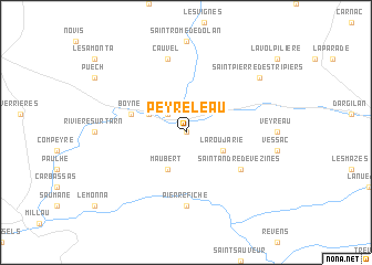
Peyreleau (Midi-Pyrénées, France)Peyreleau is a town in the Midi-Pyrénées region of France. An overview map of the region around Peyreleau is displayed below.
regional and 3d topo map of Peyreleau, France ::
Peyreleau airports ::
The nearest airport is MEN - Mende Brenoux, located 43.5 km north east of Peyreleau.
Other airports nearby include RDZ - Rodez Marcillac (63.7 km north west), MPL - Montpellier Mediterranee (90.3 km south east), LBI - Albi Le Sequestre (93.4 km west), BZR - Beziers Vias (96.2 km south), Nearby towns ::
Le Rozier (0.0km north) //
Liaucous (2.3km north west) //
La Roujarie (3.2km south east) //
Maubert (3.9km south) //
Mostuéjouls (3.2km north west) //
Boyne (4.4km north west) //
Saint-André-de-Vézines (5.4km south east) //
Pierrefiche (7.4km south) //
La Roque-Sainte-Marguerite (7.4km south) //
Cauvel (7.5km north) //
Saint-Pierre-des-Tripiers (7.7km north east) //
[all distances 'as the bird flies' and approximate] 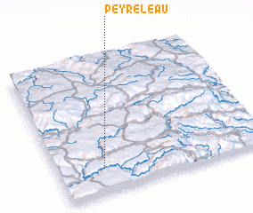 Places with similar names to Peyreleau, France ::
Disclaimer :: Information on this page comes without warranty of any kind |
||
|
Where is Peyreleau? Elevation and coordinates ::
Latitude (lat): 44°11'0"N Longitude (lon): 3°13'0"E
Elevation (approx.): 725m (map arrows pan, magnifying glasses zoom) |
||
|
Visiting Peyreleau? Hotel/Accommodation ::
Book a hotel in Peyreleau Travel Guide ::
Buy a travel guide for France rental cars ::
car rental offers GPS waypoint ::
download a GPX waypoint (PoI) of Peyreleau for your GPS receiver
|
||