|
search place name
|
||
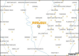
Pirajoux (Rhône-Alpes, France)Pirajoux is a town in the Rhône-Alpes region of France. An overview map of the region around Pirajoux is displayed below.
regional and 3d topo map of Pirajoux, France ::
Pirajoux airports ::
The nearest airport is XBK - Bourg Ceyzeriat, located 20.3 km south of Pirajoux.
Other airports nearby include QNX - Macon Charnay (40.0 km west), XCD - Chalon Champforgeuil (61.5 km north west), GVA - Geneva Cointrin (64.4 km east), DLE - Dole Tavaux (73.5 km north), Nearby towns ::
Domsure (3.7km north) //
Villemotier (3.9km south) //
Chazelles (3.2km north east) //
Beaupont (3.2km north west) //
Coligny (3.8km east) //
Salavre (4.3km south east) //
Bény (5.7km south) //
Verjon (5.3km south east) //
Nanc (5.3km north east) //
Marboz (6.8km south west) //
Saint-Amour (6.8km north east) //
Saint-Jean-dʼÉtreux (6.3km north east) //
Courmangoux (7.6km south east) //
LʼAubépin (7.6km north east) //
Balanod (9.0km north east) //
Cormoz (9.0km north west) //
[all distances 'as the bird flies' and approximate]  Places with similar names to Pirajoux, France :: Disclaimer :: Information on this page comes without warranty of any kind |
||
|
Where is Pirajoux? Elevation and coordinates ::
Latitude (lat): 46°23'0"N Longitude (lon): 5°18'0"E
Elevation (approx.): 213m (map arrows pan, magnifying glasses zoom) |
||
|
Visiting Pirajoux? Hotel/Accommodation ::
Book a hotel in Pirajoux Travel Guide ::
Buy a travel guide for France rental cars ::
car rental offers GPS waypoint ::
download a GPX waypoint (PoI) of Pirajoux for your GPS receiver
|
||