|
search place name
|
||
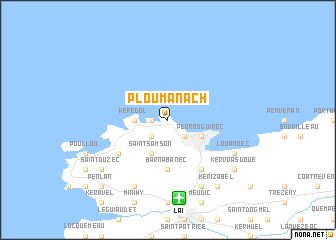
Ploumanacʼh (Bretagne, France)Ploumanacʼh is a town in the Bretagne region of France. An overview map of the region around Ploumanacʼh is displayed below.
regional and 3d topo map of Ploumanacʼh, France ::
Ploumanacʼh airports ::
The nearest airport is LAI - Lannion, located 8.8 km south of Ploumanacʼh.
Other airports nearby include MXN - Morlaix Ploujean (35.4 km south west), SBK - St.-brieuc Armor Armor (56.8 km south east), BES - Brest Guipavas (81.2 km south west), GCI - Guernsey (92.8 km north east), Nearby towns ::
Sainte-Anne (1.2km west) //
La Clarté (2.2km south east) //
Trestraou (2.2km south east) //
Trégastel (2.2km south west) //
Poul Arhy (2.2km south west) //
Kerédol (2.4km west) //
Trégastel-Plage (2.4km west) //
Perros-Guirec (3.1km south east) //
Saint-Samson (3.9km south) //
Barnabanec (5.6km south) //
Saint-Quay-Perros (6.1km south east) //
Kerdadraon (5.2km south west) //
Cité (7.8km south) //
Louannec (6.1km south east) //
Pleumeur-Bodou (7.8km south) //
Kerizabel (8.3km south east) //
Kervoas Doué (7.4km south east) //
Saint-Duzec (7.4km south west) //
Penlan (8.9km south west) //
[all distances 'as the bird flies' and approximate]  Places with similar names to Ploumanacʼh, France ::
// Pa-lu-mo-an-she (TW)
Disclaimer :: Information on this page comes without warranty of any kind |
||
|
Where is Ploumanacʼh? Elevation and coordinates ::
Latitude (lat): 48°50'0"N Longitude (lon): 3°29'0"W
Elevation (approx.): 15m (map arrows pan, magnifying glasses zoom) |
||
|
Visiting Ploumanacʼh? Hotel/Accommodation ::
Book a hotel in Ploumanacʼh Travel Guide ::
Buy a travel guide for France rental cars ::
car rental offers GPS waypoint ::
download a GPX waypoint (PoI) of Ploumanacʼh for your GPS receiver
|
||