|
search place name
|
||
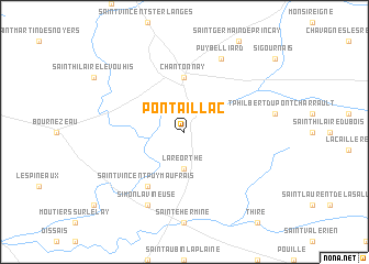
Pontaillac (Aquitaine, France)Pontaillac is a town in the Aquitaine region of France. An overview map of the region around Pontaillac is displayed below.
regional and 3d topo map of Pontaillac, France ::
Pontaillac airports ::
The nearest airport is EDM - La Roche-sur-yon Les Ajoncs, located 26.3 km west of Pontaillac.
Other airports nearby include CET - Cholet Le Pontreau (51.6 km north), NIT - Niort Souche (61.3 km south east), NTE - Nantes Atlantique (71.9 km north west), RCO - Rochefort St Agnant (83.0 km south), Nearby towns ::
La Réorthe (3.7km south) //
Chantonnay (5.6km north) //
Saint-Vincent-Puymaufrais (6.1km south west) //
Simon-la-Vineuse (7.8km south) //
Puybelliard (7.8km north) //
[all distances 'as the bird flies' and approximate]  Places with similar names to Pontaillac, France ::
// Pantalica (IT)
// Paint Lick (US)
// Paintlick (US)
// Pindilig (EC)
// Pondlick (US)
// Pondelok (SK)
// Pantalaca (BO)
// Pontaillac (FR)
// Ponta Lagoa (GW)
Disclaimer :: Information on this page comes without warranty of any kind |
||
|
Where is Pontaillac? Elevation and coordinates ::
Latitude (lat): 46°38'0"N Longitude (lon): 1°3'0"W
Elevation (approx.): 101m (map arrows pan, magnifying glasses zoom) |
||
|
Visiting Pontaillac? Hotel/Accommodation ::
Book a hotel in Pontaillac Travel Guide ::
Buy a travel guide for France rental cars ::
car rental offers GPS waypoint ::
download a GPX waypoint (PoI) of Pontaillac for your GPS receiver
|
||