|
search place name
|
||
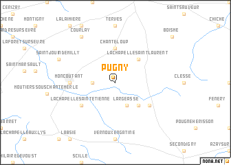
Pugny (Poitou-Charentes, France)Pugny is a town in the Poitou-Charentes region of France. An overview map of the region around Pugny is displayed below.
regional and 3d topo map of Pugny, France ::
Pugny airports ::
The nearest airport is NIT - Niort Souche, located 45.9 km south of Pugny.
Other airports nearby include CET - Cholet Le Pontreau (49.0 km north west), PIS - Poitiers Biard (64.6 km east), EDM - La Roche-sur-yon Les Ajoncs (65.9 km west), NTE - Nantes Atlantique (96.4 km north west), Nearby towns ::
Le Breuil-Bernard (2.5km west) //
Largeasse (3.9km south) //
La Chapelle-Saint-Laurent (4.5km north east) //
Trayes (4.5km south east) //
Chanteloup (5.6km north) //
La Chapelle-Saint-Étienne (5.3km south west) //
Neuvy-Bouin (5.3km south east) //
Moncoutant (5.1km west) //
Courlay (8.3km north west) //
[all distances 'as the bird flies' and approximate] 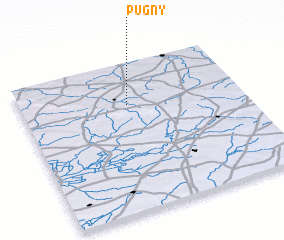 Places with similar names to Pugny, France ::
Disclaimer :: Information on this page comes without warranty of any kind |
||
|
Where is Pugny? Elevation and coordinates ::
Latitude (lat): 46°43'0"N Longitude (lon): 0°31'0"W
Elevation (approx.): 175m (map arrows pan, magnifying glasses zoom) |
||
|
Visiting Pugny? Hotel/Accommodation ::
Book a hotel in Pugny Travel Guide ::
Buy a travel guide for France rental cars ::
car rental offers GPS waypoint ::
download a GPX waypoint (PoI) of Pugny for your GPS receiver
|
||