|
search place name
|
||
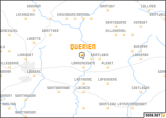
Quérien (Bretagne, France)Quérien is a town in the Bretagne region of France. An overview map of the region around Quérien is displayed below.
regional and 3d topo map of Quérien, France ::
Quérien airports ::
The nearest airport is SBK - St.-brieuc Armor Armor, located 40.5 km north of Quérien.
Other airports nearby include VNE - Vannes Meucon (53.3 km south), DNR - Dinard Pleurtuit (60.3 km north east), RNS - Rennes St Jacques (69.6 km east), LRT - Lorient Lann Bihoue (76.6 km south west), Nearby towns ::
Le Vaublanc (1.2km east) //
La Prénessaye (1.9km south) //
Saint-Lubin (2.5km east) //
Lanthenac (5.6km south) //
Plémet (4.1km south east) //
La Chèze (7.4km south) //
La Ferrière (6.7km south east) //
Ville Hermel (7.4km north east) //
Saint-Théo (7.4km north west) //
Saint-Barnabé (8.3km south west) //
Saint-Gouéno (8.9km north east) //
[all distances 'as the bird flies' and approximate] 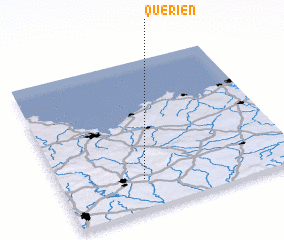 Places with similar names to Quérien, France ::
Disclaimer :: Information on this page comes without warranty of any kind |
||
|
Where is Quérien? Elevation and coordinates ::
Latitude (lat): 48°12'0"N Longitude (lon): 2°39'0"W
Elevation (approx.): 124m (map arrows pan, magnifying glasses zoom) |
||
|
Visiting Quérien? Hotel/Accommodation ::
Book a hotel in Quérien Travel Guide ::
Buy a travel guide for France rental cars ::
car rental offers GPS waypoint ::
download a GPX waypoint (PoI) of Quérien for your GPS receiver
|
||