|
search place name
|
||
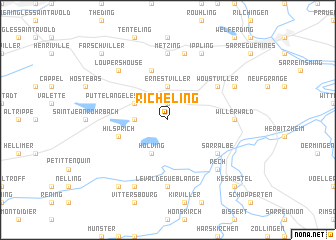
Richeling (Lorraine, France)Richeling is a town in the Lorraine region of France. An overview map of the region around Richeling is displayed below.
regional and 3d topo map of Richeling, France ::
Richeling airports ::
The nearest airport is SCN - Saarbruecken Saarbrucken, located 22.7 km north east of Richeling.
Other airports nearby include ETZ - Metz Nancy Lorraine (52.6 km west), MZM - Metz Frescaty (61.2 km west), RMS - Ramstein Ab (64.4 km north east), ENC - Nancy Essey (66.0 km south west), Nearby towns ::
Grundviller (1.9km north) //
Ernestviller (3.7km north) //
Rémering-lès-Puttelange (2.4km west) //
Holving (3.9km south) //
Puttelange-lès-Farschviller (3.1km north west) //
Hilsprich (4.1km south west) //
Guebenhouse (5.7km north) //
Sarralbe (5.2km south east) //
Woustviller (5.2km north east) //
Willerwald (4.9km east) //
Le Val-de-Guéblange (7.4km south) //
Metzing (7.4km north) //
Hundling (7.5km north) //
Loupershouse (6.6km north west) //
Rech (6.6km south east) //
Hambach (6.1km north east) //
Hazembourg (7.8km south) //
Ippling (7.8km north) //
Kappelkinger (8.3km south west) //
Keskastel (8.9km south east) //
Farschviller (8.9km north west) //
[all distances 'as the bird flies' and approximate] 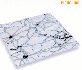
Disclaimer :: Information on this page comes without warranty of any kind |
||
|
Where is Richeling? Elevation and coordinates ::
Latitude (lat): 49°2'0"N Longitude (lon): 6°58'0"E
Elevation (approx.): 228m (map arrows pan, magnifying glasses zoom) |
||
|
Visiting Richeling? Hotel/Accommodation ::
Book a hotel in Richeling Travel Guide ::
Buy a travel guide for France rental cars ::
car rental offers GPS waypoint ::
download a GPX waypoint (PoI) of Richeling for your GPS receiver
|
||