|
search place name
|
||
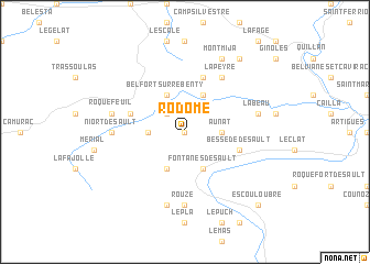
Rodome (Languedoc-Roussillon, France)Rodome is a town in the Languedoc-Roussillon region of France. An overview map of the region around Rodome is displayed below.
regional and 3d topo map of Rodome, France ::
Rodome airports ::
The nearest airport is CCF - Carcassonne Salvaza, located 50.2 km north east of Rodome.
Other airports nearby include PGF - Perpignan Rivesaltes (66.1 km east), LEU - Seo De Urgel (74.4 km south west), DCM - Castres Mazamet (85.9 km north), LRH - La Rochelle Lherm (97.3 km north west), Nearby towns ::
Munès (0.0km north) //
Galinagues (2.3km north west) //
Aunat (2.7km east) //
Mazuby (2.7km west) //
Fontanès-de-Sault (3.9km south) //
Joucou (3.9km north) //
Campagna-de-Sault (3.9km south) //
Belfort-sur-Rébenty (3.9km north) //
Belvis (5.7km north) //
Bessède-de-Sault (4.5km south east) //
Espezel (4.5km north west) //
La Peyre (6.2km north east) //
Rouze (7.4km south) //
Niort-de-Sault (5.4km west) //
Labeau (5.7km east) //
Mijanès (7.5km south) //
Roquefeuil (5.7km west) //
Montmija (7.9km north) //
Coudons (8.5km north east) //
Escouloubre (9.2km south east) //
[all distances 'as the bird flies' and approximate]  Places with similar names to Rodome, France ::
// Reteïm (MA)
// Rio do Meio (BR)
// Rio do Meio (BR)
// Rātma (MM)
// Ridam (MM)
// Radium (US)
// Rittham (AT)
// Radom (US)
// Radium (US)
// Rottum (DE)
Disclaimer :: Information on this page comes without warranty of any kind |
||
|
Where is Rodome? Elevation and coordinates ::
Latitude (lat): 42°48'0"N Longitude (lon): 2°4'0"E
Elevation (approx.): 918m (map arrows pan, magnifying glasses zoom) |
||
|
Visiting Rodome? Hotel/Accommodation ::
Book a hotel in Rodome Travel Guide ::
Buy a travel guide for France rental cars ::
car rental offers GPS waypoint ::
download a GPX waypoint (PoI) of Rodome for your GPS receiver
|
||