|
search place name
|
||
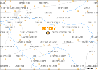
Roncey (Basse-Normandie, France)Roncey is a town in the Basse-Normandie region of France. An overview map of the region around Roncey is displayed below.
regional and 3d topo map of Roncey, France ::
Roncey airports ::
The nearest airport is JER - Jersey, located 67.7 km west of Roncey.
Other airports nearby include CFR - Caen Carpiquet (67.9 km east), DNR - Dinard Pleurtuit (70.3 km south west), CER - Cherbourg Maupertus (74.8 km north), ACI - Alderney (102.8 km north west), Nearby towns ::
Saint-Denis-le-Gast (3.7km south) //
Grimesnil (3.9km south) //
Montpinchon (3.9km north) //
Ouville (4.4km north west) //
Saint-Martin-de-Cenilly (3.6km east) //
Belval (6.1km north west) //
Savigny (7.4km north) //
Saint-Denis-le-Vêtu (4.9km west) //
La Baleine (7.5km south) //
Gavray (7.5km south) //
Le Grand Cambry (5.2km west) //
Lengronne (6.7km south west) //
Cerisy-la-Salle (6.6km north east) //
Hambye (6.1km south east) //
Sourdeval-les-Bois (8.9km south east) //
Courcy (8.9km north west) //
[all distances 'as the bird flies' and approximate] 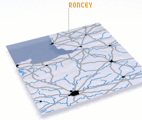 Places with similar names to Roncey, France ::
Disclaimer :: Information on this page comes without warranty of any kind |
||
|
Where is Roncey? Elevation and coordinates ::
Latitude (lat): 48°59'0"N Longitude (lon): 1°20'0"W
Elevation (approx.): 83m (map arrows pan, magnifying glasses zoom) |
||
|
Visiting Roncey? Hotel/Accommodation ::
Book a hotel in Roncey Travel Guide ::
Buy a travel guide for France rental cars ::
car rental offers GPS waypoint ::
download a GPX waypoint (PoI) of Roncey for your GPS receiver
|
||