|
search place name
|
||
Rusquec (Bretagne, France)Rusquec is a town in the Bretagne region of France. An overview map of the region around Rusquec is displayed below.
regional and 3d topo map of Rusquec, France ::

Rusquec airports ::
The nearest airport is MXN - Morlaix Ploujean, located 18.3 km east of Rusquec.
Other airports nearby include BES - Brest Guipavas (29.5 km south west), LAI - Lannion (48.3 km north east), UIP - Quimper Pluguffan (64.5 km south), SBK - St.-brieuc Armor Armor (88.3 km east), Nearby towns ::
Lambader (1.9km north) //
Le Drénec (2.2km south west) //
La Poterie (2.2km south east) //
Kerven (3.7km south) //
Plougourvest (2.5km west) //
Landivisiau (3.9km south) //
Coat-Sabiec (3.1km south west) //
Coat-ivelec (3.1km north west) //
Plouvorn (3.9km north) //
Lesvenan (3.9km north) //
Ty Nevez (4.4km south west) //
Pont Croix (5.6km south) //
Kerlaoudet (3.7km east) //
Lampaul-Guimiliau (5.7km south) //
Trémagon (4.1km north west) //
Kermat (5.2km south east) //
Quilligien (5.2km north east) //
Sainte-Catherine (7.4km north) //
Bodilis (5.2km west) //
Rocʼhfily (7.5km south) //
Traoulen (7.5km south) //
Kergoz (7.5km north) //
Kerlaviou (6.2km south east) //
Pernaman (7.8km south) //
Pen-ar-Valy (6.1km north west) //
Mespaul (7.8km north) //
Trézilidé (7.8km north) //
Guimiliau (8.3km south east) //
Créacʼh ar Bleiz (8.3km south east) //
[all distances 'as the bird flies' and approximate] 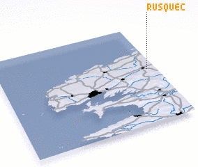 Places with similar names to Rusquec, France ::
Disclaimer :: Information on this page comes without warranty of any kind |
||
|
Where is Rusquec? Elevation and coordinates ::
Latitude (lat): 48°33'0"N Longitude (lon): 4°3'0"W
Elevation (approx.): 112m (map arrows pan, magnifying glasses zoom) |
||
|
Visiting Rusquec? Hotel/Accommodation ::
Book a hotel in Rusquec Travel Guide ::
Buy a travel guide for France rental cars ::
car rental offers GPS waypoint ::
download a GPX waypoint (PoI) of Rusquec for your GPS receiver
|
||