|
search place name
|
||
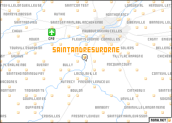
Saint-André-sur-Orne (Basse-Normandie, France)Saint-André-sur-Orne is a town in the Basse-Normandie region of France. An overview map of the region around Saint-André-sur-Orne is displayed below.
regional and 3d topo map of Saint-André-sur-Orne, France ::
Saint-André-sur-Orne airports ::
The nearest airport is CFR - Caen Carpiquet, located 8.0 km north west of Saint-André-sur-Orne.
Other airports nearby include DOL - Deauville St Gatien (47.9 km north east), LEH - Le Havre Octeville (57.7 km north east), CER - Cherbourg Maupertus (98.7 km north west), URO - Rouen Vallee De Seine (117.3 km east), Nearby towns ::
Saint-Martin-de-Fontenay (1.2km east) //
Feuguerolles-sur-Orne (1.2km west) //
Étavaux (2.2km north west) //
May-sur-Orne (2.2km south east) //
Fleury-sur-Orne (3.7km north) //
Laize-la-Ville (3.7km south) //
Ifs (3.1km north east) //
Fontenay-le-Marmion (3.1km south east) //
Maltot (3.1km north west) //
Bully (3.1km south west) //
Clinchamps-sur-Orne (3.9km south) //
Louvigny (5.6km north) //
Fresney-le-Puceux (5.7km south) //
Vieux (4.1km south west) //
Éterville (5.2km north west) //
Cormelles (5.2km north east) //
Faubourg de Vaucelles (6.1km north east) //
Bretteville-sur-Odon (6.1km north west) //
Amayé-sur-Orne (5.2km south west) //
Mutrécy (6.1km south west) //
Hubert-Folie (5.2km east) //
Saint-Germain-la-Blanche-Herbe (7.5km north) //
Rocquancourt (5.2km east) //
Boulon (7.5km south) //
Caen (7.8km north) //
Verson (6.1km north west) //
Fontaine-Étoupefour (6.1km north west) //
Saint-Laurent-de-Condel (7.8km south) //
Mondeville (7.4km north east) //
[all distances 'as the bird flies' and approximate]  Places with similar names to Saint-André-sur-Orne, France :: Disclaimer :: Information on this page comes without warranty of any kind |
||
|
Where is Saint-André-sur-Orne? Elevation and coordinates ::
Latitude (lat): 49°7'0"N Longitude (lon): 0°23'0"W
Elevation (approx.): 22m (map arrows pan, magnifying glasses zoom) |
||
|
Visiting Saint-André-sur-Orne? Hotel/Accommodation ::
Book a hotel in Saint-André-sur-Orne Travel Guide ::
Buy a travel guide for France rental cars ::
car rental offers GPS waypoint ::
download a GPX waypoint (PoI) of Saint-André-sur-Orne for your GPS receiver
|
||