|
search place name
|
||
Saint-Benoît-des-Ombres (Haute-Normandie, France)Saint-Benoît-des-Ombres is a town in the Haute-Normandie region of France. An overview map of the region around Saint-Benoît-des-Ombres is displayed below.
regional and 3d topo map of Saint-Benoît-des-Ombres, France ::

Saint-Benoît-des-Ombres airports ::
The nearest airport is DOL - Deauville St Gatien, located 37.8 km north west of Saint-Benoît-des-Ombres.
Other airports nearby include URO - Rouen Vallee De Seine (42.8 km north east), LEH - Le Havre Octeville (51.8 km north west), CFR - Caen Carpiquet (79.2 km west), POX - Pontoise Cormeilles En Vexin (103.8 km east), Nearby towns ::
Neuville-sur-Authou (1.9km south) //
Saint-Grégoire-du-Vièvre (1.9km north) //
Livet-sur-Authou (2.4km east) //
Saint-Pierre-des-Ifs (3.7km north) //
Saint-Victor-dʼÉpine (3.0km south west) //
Freneuse-sur-Risle (3.0km north east) //
Notre-Dame-dʼÉpine (4.4km south west) //
Saint-Pierre-de-Salerne (4.4km south east) //
Brétigny (4.1km south east) //
Saint-Georges-du-Vièvre (4.1km north west) //
Saint-Philbert-sur-Risle (5.7km north) //
Saint-Christophe-sur-Condé (6.1km north west) //
Saint-Cyr-de-Salerne (6.1km south east) //
Glos-sur-Risle (5.2km north east) //
Authou (4.8km east) //
Saint-Jean-de-la-Léqueraye (5.2km west) //
Pont-Authou (5.2km east) //
Morsan (6.6km south west) //
Giverville (6.1km south west) //
Hecmanville (7.8km south) //
Montfort-sur-Risle (7.8km north) //
Boissy-Lamberville (8.3km south west) //
Saint-Martin-Saint-Firmin (7.4km north west) //
Aclou (8.9km south east) //
Franqueville (8.9km south east) //
[all distances 'as the bird flies' and approximate] 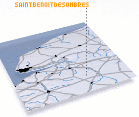 Places with similar names to Saint-Benoît-des-Ombres, France :: Disclaimer :: Information on this page comes without warranty of any kind |
||
|
Where is Saint-Benoît-des-Ombres? Elevation and coordinates ::
Latitude (lat): 49°14'0"N Longitude (lon): 0°38'0"W
Elevation (approx.): 117m (map arrows pan, magnifying glasses zoom) |
||
|
Visiting Saint-Benoît-des-Ombres? Hotel/Accommodation ::
Book a hotel in Saint-Benoît-des-Ombres Travel Guide ::
Buy a travel guide for France rental cars ::
car rental offers GPS waypoint ::
download a GPX waypoint (PoI) of Saint-Benoît-des-Ombres for your GPS receiver
|
||