|
search place name
|
||
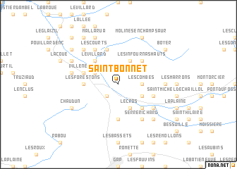
Saint-Bonnet (Provence-Alpes-Côte dʼAzur, France)Saint-Bonnet is a town in the Provence-Alpes-Côte dʼAzur region of France. An overview map of the region around Saint-Bonnet is displayed below.
regional and 3d topo map of Saint-Bonnet, France ::
Saint-Bonnet airports ::
The nearest airport is VAF - Valence Chabeuil, located 92.0 km west of Saint-Bonnet.
Other airports nearby include GNB - Grenoble Saint Geoirs (96.1 km north west), CMF - Chambery Aix Les Bains (107.3 km north), CUF - Levaldigi (123.2 km east), AVN - Avignon Caumont (127.8 km south west), Nearby towns ::
La Fare-en-Champsaur (2.3km south west) //
Les Combes (2.6km east) //
Poligny (3.2km north west) //
Le Cros (3.9km south) //
Les Chanets (3.2km south east) //
Les Infournas (3.9km north) //
Le Villard (4.5km north west) //
Saint-Laurent-du-Cros (4.5km south east) //
Les Infournas Hauts (4.5km north east) //
Les Forestons (4.0km west) //
Laye (5.6km south) //
La Motte-en-Champsaur (5.7km north) //
Saint-Julien-en-Champsaur (4.4km south east) //
Chantaussel (4.4km south east) //
Villeneuve (4.4km north west) //
Les Courts (6.2km north west) //
Buissard (5.4km south east) //
Forest-Saint-Julien (5.4km south east) //
Serre Richard (6.2km south east) //
Chaillolet (5.3km east) //
Le Noyer (5.6km west) //
Saint-Eusèbe-en-Champsaur (6.8km north west) //
Manse (6.8km south east) //
Chaudun (6.4km south west) //
Les Évarras (6.4km north west) //
Mallarua (7.9km north) //
Molines-en-Champsaur (7.9km north) //
Aubessagne (7.7km north west) //
Boyer (7.7km north east) //
[all distances 'as the bird flies' and approximate] 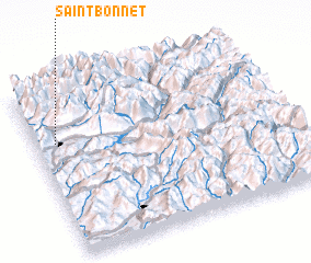 Places with similar names to Saint-Bonnet, France ::
// Sandy Bend (US)
// Saint-Benoît (CG)
// Sainte Benoit (GA)
// Saint-Bonnot (FR)
// SantʼAbundio (IT)
// Zando Bānda (PK)
// Saint-Bonnet (FR)
// Saint-Bonnet (FR)
// Saint-Benoît (FR)
// Saint-Benoît (FR)
Disclaimer :: Information on this page comes without warranty of any kind |
||
|
Where is Saint-Bonnet? Elevation and coordinates ::
Latitude (lat): 44°41'0"N Longitude (lon): 6°5'0"E
Elevation (approx.): 1068m (map arrows pan, magnifying glasses zoom) |
||
|
Visiting Saint-Bonnet? Hotel/Accommodation ::
Book a hotel in Saint-Bonnet Travel Guide ::
Buy a travel guide for France rental cars ::
car rental offers GPS waypoint ::
download a GPX waypoint (PoI) of Saint-Bonnet for your GPS receiver
|
||