|
search place name
|
||
Sainte-Marie-de-Cuines (Rhône-Alpes, France)Sainte-Marie-de-Cuines is a town in the Rhône-Alpes region of France. An overview map of the region around Sainte-Marie-de-Cuines is displayed below.
regional and 3d topo map of Sainte-Marie-de-Cuines, France ::

Sainte-Marie-de-Cuines airports ::
The nearest airport is CMF - Chambery Aix Les Bains, located 47.2 km north west of Sainte-Marie-de-Cuines.
Other airports nearby include NCY - Annecy Meythet (68.1 km north), GNB - Grenoble Saint Geoirs (76.1 km west), QNJ - Annemasse (95.5 km north), GVA - Geneva Cointrin (101.6 km north), Nearby towns ::
Champagnes (1.3km east) //
Le Pinay (2.3km south west) //
Le Tremble (2.3km north west) //
Saint-Étienne-de-Cuines (2.3km north west) //
Saint-Avre (2.3km north east) //
Montbrunal (2.6km east) //
Le Monthion (2.6km west) //
La Chambre (3.7km north) //
Le Noirey (3.2km south east) //
Le Premier Villard (3.2km south west) //
Pontamafrey (3.2km south east) //
Notre-Dame-du-Cruet (3.9km north) //
Saint-Martin-sur-le-Chambre (3.9km north) //
Le Bouchet (4.5km south west) //
Saint-Alban-des-Villards (4.3km south west) //
Montvernier (4.3km south east) //
Jarrier (5.7km south) //
Montgellafrey (5.7km north) //
Les Chavannes-le Milieu (5.7km north) //
Les Chavannes (5.7km north) //
Les Chavannes-Dessus (5.7km north) //
La Girard (6.1km north west) //
Le Replat (5.4km north west) //
Montaimont (5.4km north east) //
Montpascal (5.2km east) //
Les Martinières (7.5km north) //
Saint-Jean-de-Maurienne (6.8km south east) //
La Perrière (6.8km north east) //
Saint-Pancrace (7.9km south) //
[all distances 'as the bird flies' and approximate] 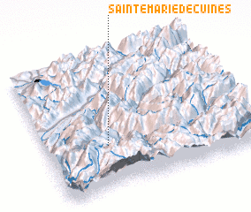 Places with similar names to Sainte-Marie-de-Cuines, France :: Disclaimer :: Information on this page comes without warranty of any kind |
||
|
Where is Sainte-Marie-de-Cuines? Elevation and coordinates ::
Latitude (lat): 45°20'0"N Longitude (lon): 6°18'0"E
Elevation (approx.): 551m (map arrows pan, magnifying glasses zoom) |
||
|
Visiting Sainte-Marie-de-Cuines? Hotel/Accommodation ::
Book a hotel in Sainte-Marie-de-Cuines Travel Guide ::
Buy a travel guide for France rental cars ::
car rental offers GPS waypoint ::
download a GPX waypoint (PoI) of Sainte-Marie-de-Cuines for your GPS receiver
|
||