|
search place name
|
||
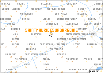
Saint-Maurice-sur-Dargoire (Rhône-Alpes, France)Saint-Maurice-sur-Dargoire is a town in the Rhône-Alpes region of France. An overview map of the region around Saint-Maurice-sur-Dargoire is displayed below.
regional and 3d topo map of Saint-Maurice-sur-Dargoire, France ::
Saint-Maurice-sur-Dargoire airports ::
The nearest airport is EBU - St.-etienne Boutheon, located 26.7 km west of Saint-Maurice-sur-Dargoire.
Other airports nearby include LYN - Lyon Bron (29.0 km north east), XVF - Vilefrance Tarare (35.4 km north), LYS - Lyon Saint Exupery (39.0 km north east), GNB - Grenoble Saint Geoirs (59.7 km south east), Nearby towns ::
La Fillonnière (1.9km north) //
Saint-Jean-de-Touslas (2.6km east) //
Saint-Sorlin (3.7km north) //
Saint-Joseph (3.9km south) //
Saint-Didier-sous-Riverie (3.2km north west) //
Riverie (3.2km north west) //
Dargoire (3.2km south east) //
Tartaras (4.5km south east) //
Mornant (4.5km north east) //
Chaussan (5.6km north) //
Flassieux (3.9km west) //
Rive-de-Gier (5.7km south) //
Le Glas (5.7km north) //
Châteauneuf (5.7km south) //
Saint-André-la-Côte (6.1km north west) //
Saint-Martin-la-Plaine (6.1km south west) //
Tréves (6.1km south east) //
Saint-Andéol-le-Château (5.2km east) //
Couzon (7.5km south) //
Sainte-Catherine-sous-Riverie (5.5km west) //
Saint-Laurent-dʼAgny (6.8km north east) //
La Cula (6.4km south west) //
Disimieux (7.9km south) //
Saint-Vincent (7.9km north) //
Le Logis Neuf (6.4km north east) //
Tapigneux (7.6km south west) //
Lorette (8.4km south west) //
Leymieux (7.6km south west) //
Saint-Genis-Terrenoire (8.4km south west) //
[all distances 'as the bird flies' and approximate]  Places with similar names to Saint-Maurice-sur-Dargoire, France :: Disclaimer :: Information on this page comes without warranty of any kind |
||
|
Where is Saint-Maurice-sur-Dargoire? Elevation and coordinates ::
Latitude (lat): 45°35'0"N Longitude (lon): 4°38'0"E
Elevation (approx.): 457m (map arrows pan, magnifying glasses zoom) |
||
|
Visiting Saint-Maurice-sur-Dargoire? Hotel/Accommodation ::
Book a hotel in Saint-Maurice-sur-Dargoire Travel Guide ::
Buy a travel guide for France rental cars ::
car rental offers GPS waypoint ::
download a GPX waypoint (PoI) of Saint-Maurice-sur-Dargoire for your GPS receiver
|
||