|
search place name
|
||
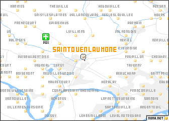
Saint-Ouen-lʼAumône (France)Saint-Ouen-lʼAumône is a town in France. An overview map of the region around Saint-Ouen-lʼAumône is displayed below.
regional and 3d topo map of Saint-Ouen-lʼAumône, France ::
Saint-Ouen-lʼAumône airports ::
The nearest airport is POX - Pontoise Cormeilles En Vexin, located 7.6 km north west of Saint-Ouen-lʼAumône.
Other airports nearby include LBG - Paris Le Bourget (25.4 km east), CDG - Paris Charles De Gaulle (32.0 km east), TNF - Toussous-le-noble Toussus Le Noble (33.2 km south), CSF - Creil (37.1 km north east), Nearby towns ::
Pontoise (1.2km west) //
Épluches (2.2km north east) //
Ennery (2.2km north west) //
Éragny (3.9km south) //
Hérouville (5.7km north) //
Cergy (4.1km south west) //
Auvers-sur-Oise (4.1km north east) //
Osny (4.1km north west) //
Livilliers (5.7km north) //
Pierrelaye (5.2km south east) //
Neuville-sur-Oise (5.2km south west) //
Génicourt (5.2km north west) //
Conflans-Sainte-Honorine (7.5km south) //
Herblay (6.6km south east) //
Maurecourt (6.6km south west) //
Andrésy (8.3km south west) //
Épiais-Rhus (8.3km north west) //
Montigny-lès-Cormeilles (8.9km south east) //
[all distances 'as the bird flies' and approximate]  Places with similar names to Saint-Ouen-lʼAumône, France :: Disclaimer :: Information on this page comes without warranty of any kind |
||
|
Where is Saint-Ouen-lʼAumône? Elevation and coordinates ::
Latitude (lat): 49°3'0"N Longitude (lon): 2°7'0"E
Elevation (approx.): 25m (map arrows pan, magnifying glasses zoom) |
||
|
Visiting Saint-Ouen-lʼAumône? Hotel/Accommodation ::
Book a hotel in Saint-Ouen-lʼAumône Travel Guide ::
Buy a travel guide for France rental cars ::
car rental offers GPS waypoint ::
download a GPX waypoint (PoI) of Saint-Ouen-lʼAumône for your GPS receiver
|
||