|
search place name
|
||
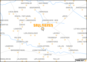
Saulnières (Bretagne, France)Saulnières is a town in the Bretagne region of France. An overview map of the region around Saulnières is displayed below.
regional and 3d topo map of Saulnières, France ::
Saulnières airports ::
The nearest airport is RNS - Rennes St Jacques, located 20.4 km north west of Saulnières.
Other airports nearby include LVA - Laval Entrammes (64.0 km east), SNR - St.-nazaire Montoir (79.5 km south west), DNR - Dinard Pleurtuit (83.2 km north west), NTE - Nantes Atlantique (84.9 km south), Nearby towns ::
Le Petit-Fougeray (2.2km north west) //
Le Beauchêne (3.9km north) //
Le Sel (3.1km south west) //
Tresboeuf (4.5km south east) //
La Bosse-de-Bretagne (5.7km south) //
La Croix (4.2km south east) //
Le Plessis-Léger (4.2km south west) //
Les Bruyères (6.1km south east) //
La Boissière (5.3km north west) //
Brie (5.3km north east) //
Chanteloup (6.1km north west) //
Corps-Nuds (7.4km north) //
Le Val Giffard (7.4km south) //
Fortjoual (7.5km north west) //
Lalleu (8.9km south east) //
[all distances 'as the bird flies' and approximate] 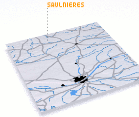 Places with similar names to Saulnières, France ::
// Salineiras (PT)
// Saulnières (FR)
Disclaimer :: Information on this page comes without warranty of any kind |
||
|
Where is Saulnières? Elevation and coordinates ::
Latitude (lat): 47°55'0"N Longitude (lon): 1°35'0"W
Elevation (approx.): 90m (map arrows pan, magnifying glasses zoom) |
||
|
Visiting Saulnières? Hotel/Accommodation ::
Book a hotel in Saulnières Travel Guide ::
Buy a travel guide for France rental cars ::
car rental offers GPS waypoint ::
download a GPX waypoint (PoI) of Saulnières for your GPS receiver
|
||